Figure 1. Illustrates the significance of the wildfire's path across major areas in and around the city of Cloquet.
On October 10, 1918, Minnesota experienced an extraordinary wildfire started by a simple spark of a train. This small spark would create large effects that would destroy the land and change history forever. A few conditions must be met for a wildfire to occur- dry fuel from organic materials, oxygen in the air, and high heat. These factors allowed this tragedy to ensue due to the drought in the area and strong, dry winds. Not only was Minnesota experiencing a drought, but the logging industry littered the countryside with dry lumber, making it an easy target for the fire to ignite and spread. The fire began in the afternoon and lasted all of 15 hours.
Figure 2. Reveals the remnants of trees and one of the few buildings to remain standing.
According to the Weather Bureau, winds reached speeds up to 76 miles per hour that evening, allowing the fire to spread rapidly across the land. The wildfire was not contained in the city of Cloquet, rather spreading to areas in Moose Lake and Kettle River. Those able to evacuate in time watched as homes exploded into flames that reached a height of 100 ft. The community of Cloquet received warning of the threat from the sounds of factory whistles and operators who phoned every citizen. The town mayor organized the arrival of evacuation trains which would ultimately transport 7,000 people out of danger. The main loss of life occurred in Moose Lake and surrounding areas where the thought of escape was too late. In total, 250,000 acres burned and over 450 people died. An estimated 73 million dollars’ worth of damage wreaked over the community.
Figure 3. The severity of the wildfire is seen by the intense flattening of the city and tumultuous debris.
This natural disaster has been recorded as one of the worst
in United States history. The immense loss, pain, and suffering of these
communities will be forever haunting, but can be used as a lesson for the
future. Almost everyone in the city of Cloquet survived, thanks to the undying
concern of the city mayor who sprung to action amidst the chaos and terror. If
it weren’t for the four evacuation trains, many would have no other option but
to remain and burn with their possessions. Unfortunately, much of this disaster
could have potentially been avoided, had the lumber industry handled their
waste more seriously. With the knowledge of a drought that had been affecting
the area for the summer and fall months, workers should have been more aware of
their surroundings. Dry lumber encompassed the countryside fields and brush for
miles, creating a dangerous trail of hazards. The wildfire quickly became
unpredictable which made it difficult to alert surrounding areas (along with
the lack of technological resources at this day in age). The most important piece
to take from this horror is for communities to fully understand the
significance of mitigation and safety in their environment. Knowing the signs
of hazards is a crucial step in preventing deaths and economic suffering.
The video above gives a brief overall summary of the tragedy that hit the cities of Cloquet, Moose Lake, and Kettle River. The narrator emphasizes the effects of the lumber industry in the area and how this lead to concerns.
On 4 April 4, 2019, an apparent transformer spark near a resort in the mountainous region along the northeast coast of the Republic of Korea started a historic wildfire in South Korea. The wind-driven (~45mph) wildfire engulfed the border town of Sokch and stretched further along the southern Gangwon province coast near Donghae (JPSS SOC, 2019). The fire lasted until April 6, 2019.
A view of the fire that broke out a day earlier strikes the mountains of Gangneung, ~150 miles east of Seoul, South Korea, early 05 April 2019 (NST, 2019)
Destruction:
By the time 13,000 firefighters had put out most of the blaze, two people had died, dozens were injured, and almost 5,000 were displaced while nearly 500 homes and buildings were destroyed or damaged, thousands of livestock were lost, and two square miles of forest had burned (Volvo, 2020). Thousands of rescue officials came from across the nation to aid the vast range burned behind. South Korea is still coping with the damage as this wildfire was the most historic to occur on their soil. Finance Minister Hong Nam-ki estimates they have received $3.7 million in emergency aid and recovery efforts combined.
The fire starts in Goseong located ~130 miles from Seoul and is seen approaching a gas station
The fire is seen raging near buildings in Sokcho, South Korea (Kangwon Ilbo via Getty Images)
Discussion:
The cause of this multi-day event is still under investigation though many believe a fallen electrical wire is the cause. An electrical arc set the dry fuel below ablaze when knocked down during extreme winds that night. It is speculated that the increased friction between the connecting wires and utility poles caused sparks that ignited the mountain fire (KBS, 2019). One of the constricted wires was actually exposed which further contributed to the disaster. The energy company responsible, Korea Electric Power Corporation of poor construction and frequent mismanagement. Though no cause has been confirmed, this tragedy may have been prevented if there had been proper management and observation of the utility poles.
This video covers the beginning of the wildfire that was not yet extinguished during this newscast. A reporter live from the Central Disaster and Safety Measures Headquarters in Goseong county speaks on the suspected cause, damage thus far, and the areas still in danger.
Sources
JPSS SSEC. (2019, April 5). Satellite-based Disaster Outreach Coordinator (SDOC). 4 April 2019 wildfires in South Korea. Retrieved December 7, 2022, from https://www.ssec.wisc.edu/jpss-sdoc/posts/4-april-2019-south-korea-wildfires/4-april-2019-wildfires-in-south-korea/
KBS World. (2019, April 19). Electric arc believed to have caused Goseong Mountain fires. Retrieved December 8, 2022, from http://world.kbs.co.kr/service/news_view.htm?lang=e&Seq_Code=144583
NST. (2019, April 5). Firefighters contain most of S.Korean wildfires; hundreds evacuated ... Retrieved December 7, 2022, from https://www.nst.com.my/world/2019/04/476604/firefighters-contain-most-skorean-wildfires-hundreds-evacuated
Volvo. (2020, June 20). Goseong rises from the ashes of a devastating wildfire. Retrieved December 8, 2022, from https://www.volvoce.com/global/en/building-tomorrow/building-tomorrow-project/building-tomorrow-project/goseong-rises-from-the-ashes/
Figure 1. Illustrates affected areas surrounding Indonesia and depicts those most devastated by the disaster.
The Boxing Day Tsunami of 2004
Following Christmas day, on December 26, 2004, an undersea fault in the Indian Ocean released its pressure in the form of a 9.1 magnitude earthquake which would send waves with tremendous heights to the shores of Sumatra. “According to USGS scientists, the sea floor near the earthquake was uplifted several meters and the displacement of water above the sea floor triggered the tsunami.” (USGS, 2014) The tsunami reached heights of up to 100 feet and quickly engulfed the coastal city. Sumatra Island had a population of around 320,000 before disaster struck. This tragedy resulted in the loss of over 100,000 people.
Figure 2. Reveals extraordinary damage through the flattening of infrastructure across the land.
The speed at which this tsunami traveled made it virtually impossible to prepare for destruction. “The waves stripped vegetation from mountain sides hundreds of meters inland, capsized freighters and threw boats into trees.” (Rodgers, 2014) The waves moved at high velocity, up to 500 miles per hour as it moved to hit Thailand where another 5,400 people would perish. The disaster would not cease here. The tsunami re-routed toward the southeastern coast of India and affected the city of Chennai, killing 10,000. The nation of Sri Lanka would be devastated by destruction and death as well, with the numbers reaching 30,000. The tsunami would work tirelessly to demolish a final location eight hours later in South Africa. Up to 13 billion dollars in damages were accounted for after the disaster. (Senesac, 2019) Those who were not killed or severely injured by the tsunami became homeless or displaced. Numbers in this range reach 426,800 people. The intense devastation is largely due to the earthquake that triggered the violent tsunami. The undersea fault happened to be what is called a “megathrust” fault, where “heavy oceanic plates subduct beneath lighter continental plates.” One could compare the power of this quake to the release of thousands of atomic bombs at once. (Roos, 2018) The earthquake was so intense that it caused a change in the rotation of the Earth.
Figure 3. Demonstrates the pressure of the earthquake and the formation of tsunami waves.
The disastrous event that took place in 2004 was almost inevitable. The people of these lands had no natural warning or official warning that would give them a chance to prepare and survive the implications. These locations did not have a history with tsunamis either, so it was entirely unexpected. Though much could not be done to mitigate the impacts before disaster struck, the experience allowed for greater understanding for the future. The Hyogo Framework for Action was put into place weeks after the tsunami hit. Representatives from 168 nations worked to enhance “global cooperation for disaster risk reduction.” Advanced technology efforts have also been enacted to better alert countries for hazard risk and potential, such as ocean floor earthquake sensors. NOAA took immediate action to improve forecasting efforts. They increased the number of DART buoys in oceans as well. Today, “current forecasting models can now predict the arrival time, duration, height, and extent of flooding in specific locations for a tsunami.” (Reid, 2020)
The attached clip shows live footage from an individual on the scene of the 2004 tsunami. Viewers can see the violent waves surging onto the coast, wreaking havoc on everything in its path.
Works Cited
USGS. (2014, December 23). Indian
Ocean Tsunami Remembered - Scientists Reflect on the 2004 Indian Ocean that
Killed Thousands. Indian Ocean Tsunami Remembered - Scientists reflect on
the 2004 Indian Ocean that killed thousands | U.S. Geological Survey. Retrieved
November 1, 2022, from
https://www.usgs.gov/news/featured-story/indian-ocean-tsunami-remembered-scientists-reflect-2004-indian-ocean-killed
Rodgers, L. (2014, December
25). Indian Ocean tsunami: Then and Now. BBC News. Retrieved November 1,
2022, from https://www.bbc.com/news/world-asia-30034501
Senesac, E. (2019, December
23). The Indian Ocean Tsunami of 2004: A Wake-Up Call. National Weather
Service Heritage. Retrieved November 1, 2022, from
https://vlab.noaa.gov/web/nws-heritage/-/the-banda-aceh-tsunami-of-2004-a-wake-up-call
Roos, D. (2018, October 2).
The 2004 tsunami wiped away towns with 'mind-boggling' destruction.
History.com. Retrieved November 1, 2022, from https://www.history.com/news/deadliest-tsunami-2004-indian-ocean
Reid, K. (2020, June 4). 2004
Indian Ocean earthquake and tsunami: Facts, faqs, and how to help. World
Vision. Retrieved November 1, 2022, from
https://www.worldvision.org/disaster-relief-news-stories/2004-indian-ocean-earthquake-tsunami-facts
This map shows the island of Martinique and the eruption of Mt. Pelee (Northwest). It shows the range that the lava travelled, showing a few towns including the major city of St. Pierre to the southwest of the volcano. https://www.alamy.com/stock-photo-map-showing-the-eruption-of-mount-pelee-martinique-1902-artist-unknown-17640201.html
On May 8th, 1902, the volcano Mount Pelée had the deadliest eruption of the 20th century, killing 30,000 people in the process. Mount Pelée is a stratovolcano located at the Northwest corner of the Caribbean island of Martinique at 14.809°N, 61.166°W. It has a peak with an elevation of 4,500 feet high. Mount Pelée was a historically active volcano known as the mountain of fire by locals before the island was settled and claimed by the French. So by 1902, the people living in the village of St. Pierre and surrounding area had experienced minor activity from the volcano before. There was a small eruption on May 2nd which had smaller explosions and lit up the night skies. This smaller eruption killed some birds flying and fish were found dead, but people did not evacuate the town of St. Pierre due to both reassurances from the government and because around 50 years before there was an eruption of similar magnitude which had no effect on the town. As the days passed, the volcano continued to show signs of activity, with things like lahars coming down the mountain and destroying sugar plantations and flames coming from the peak of the volcano. Finally early in the morning on May, 8th, Mount Pelée had a violent eruption which sent a pyroclastic flow of rock, ash, and superheated gas straight to the village of St. Pierre. The flow, traveling at around 100 miles per hour, hit the city and absolutely devastated it. Buildings were leveled to the ground and all of the ~30,000 people in the village were killed except for two survivors. It is believed that most were killed by the initial impact, while others had their throats and lungs seared by the superheated gas of the pyroclastic flow. In addition to those in the village, there were around 30 ships in the harbor, most of which capsized or burned, taking most of their crew with them. The eruption left the city burning, with the ash igniting the rubble and the countless barrels of rum stored there.
The coastline of St. Pierre after the eruption, showing the buildings and still smoking village. https://www.americangeosciences.org/static/earth/benchmarks-may-8-1902-deadly-eruption-mount-pelee/Saint_Pierre_YORYM-TA0176_promo.jpg
Not near as much was known about volcanos in the early 1900s as is known now. This eruption was actually the one which led to the knowledge pyroclastic flows existed. Monitoring and activity detection is also much easier today due to the advances in technology. This has to be taken into account when looking into what could have been done to prevent so much damage with this volcano. That being said, this situation was still handled so poorly and ultimately lost many lives which could have been prevented. There are several reasons this eruption killed so many people. Many of the people living in St. Pierre believed that the volcano posed no threat due to the fact that it had shown activity on multiple occasions before, even spitting ash on the city, and had done little real harm. In addition to that, at the time there was an election going on for governor of the island, and the sitting governor was worried that if he evacuated the village, he would lose votes. So he assembled a committee of people to speak to the local newspaper. The committee assured people that there was no threat, and that the town of St. Pierre was perfectly safe. The newspaper then printed the reassurance and distributed it throughout the region. The residents, as well as government officials, assumed as well that lava flows were the only thing to possibly worry about, as there was no prior knowledge of pyroclastic flows. While the town should have been evacuated, it is hard to This of course was not the case as the village was located right in the path of a pyroclastic flow which destroyed the town. While the town should have been evacuated, it is hard to say that based on their limited knowledge of volcanic eruptions at the time. Although a tragic disaster, geologists and other earth scientists were able to learn a lot about volcanic eruptions from this disaster, and are now aware that volcanic eruptions are not dangerous solely due to lava flows. If the volcano ever shows activity again, St. Pierre will have hopefully learned from past experience and evacuate in a timely manner, though why the city was built back again right next to an active volcano, I am unsure.
This is an image of modern day St. Pierre with Mt. Pelée sitting quietly behind the village. https://volcano.si.edu/gallery/photos/GVP-10668.jpg
Video: This video provides a history of Mt. Pelee, from its formation to current activity. It explains the events of the May 8th eruption as well as continues on to mention current signs of activity from the volcano.
Iceland is known as “the land of ice and fire” (Kleeman, 2020). Iceland is located on a diverging plate boundary and rests on both the Eurasian plate and the North American plate lines. The country is also located on a mantle plume, or a mass of relatively hot and therefore less dense mantle materials that rise up from the Earth’s mantle towards the surface where it produces volcanism (Kleeman, 2020). These factors mean the island has a significant amount of volcanic activity. It has over thirty active volcanoes, as well as a number of inactive ones (Witze, 2015). One of the most important volcanoes on the island is Laki. An eruption in the late 1700s is still kept in the hearts of many Islanders.
Figure 1: This map shows the Laki volcano as well as some other volcanic areas around Iceland.
(Witze & Kanipe, 2014)
Summary
“The flood of fire flowed with the speed of a great swollen river with meltwater on a spring day,...[] Great cliffs and slabs of rock were swept along, tumbling about like large whales swimming, red-hot and glowing.”- Pastor Jón Steingrímsson describes the eruption in 1873 (Bressan, 2015)
On June 8, 1783, the ground ripped open and the Laki fissure released mass amounts of lava. These lava flows lasted for a total of eight months and the effects lingered for years all around the globe (Witze, 2015). The fissure is over 27 kilometers or 16 miles long and released over 14.7cubic kilometers, or (about 3.7 quadrillion gallons, enough to fill 330 feet deep valleys entirely) of lava (Bressan, 2015).
Figure 2: This picture shows the Laki fissure today. The eruption of 1783-1784 and the massive lava flows created the land as it is today. Today the Laki fissure is a part of the Vatnajökull National Park.
(Kleeman, 2020)
The eruption also produced large amounts of gases and ash. The gases, particularly the fluorine, poisoned the fields, meadows, and ponds, which killed 50% of all the cattle, 79% of the sheep, and 76% of the horses between 1783 and 1785 (Kleeman, 2020). It is estimated that the eruption released over 80 Mt of sulfuric acid aerosol which is 4 times more than El Chichon and 80 times more than Mount St. Helens (Oregon State University, 2010). It lead to a great famine and by 1785, roughly 20 percent of the Icelandic population had perished—from hunger, malnutrition, or diseases (Kleeman, 2020). This event killed over 2 billion people around the world (Disasters, 2015). Throughout the summer of 1783, there was a fog was seen in cities such as London, Paris, Stockholm, Rome, and beyond. People also reported a sour smell in the air, trouble breathing, and plants withering on exposure (Witze, 2015). This haze was reported as far as Syria (Oregon State University, 2010).
Figure 3: The gases released during the eruption created a fog, such as the one seen here. This fog made it hard to see and breathe and was deadly.
(Crocker, 2021)
The longevity of this event led to one of the coldest winters on record, leading to famine in many countries. Many scholars believe the effects of climate change caused by the Laki eruption, such as crop failures, helped spark the French Revolution (Bressan, 2015).
Figure 4: This is a famous image of the French Revolution. Famine and extreme weather changes from Laki could have significantly played a role in this revolution.
(Bauwens, 2011)
Discussion
The Laki disaster is imprinted in the national psyche as a kind of worst-case scenario for what natural disasters can do (Witze, 2015). The country's isolation and the significantly little amount of knowledge about volcanoes meant mitigation efforts were low. After this event, there was a greater interest in climate science and mitigation efforts. Famous figures such as Ben Franklin noted the atmospheric effects of the eruption (Oregon State University, 2010). Laki put out more lava and more gases than any other eruption in Iceland’s history, except for a 10th-century event that occurred before the country was widely settled (Witze, 2015). The Laki eruption was significant for showing that volcanic eruptions can have impacts on regions far away. This disaster helped researchers to better understand and respond to other disasters (Witze, 2015). This eruption also shows the resiliency of Icelanders. It truly amazes me how they were able to bounce back and become a thriving country again. Today, Iceland’s volcanoes are extremely well monitored and the country's civil-protection service responds almost immediately to any impending eruption. Unlike in 1783, people can sit at home and check the Icelandic Meteorological Office website for the latest news, maps, and predictions of what natural disaster might happen next (Witze, 2015).
Though the effects of this volcano were devesting, Laki is less well-known than Mount Tambara and other volcanos that have had similar influential eruptions. It makes me wonder why some natural disasters are better known than others.
Video
This video describes the 1783-1784 Laki eruption and its effects in Iceland and around the world. It explains why this event was one of the most important natural disasters of all time.
Sources
Bauwens, J. (2011, September 20). Sciency Thoughts: The dangers of a modern Laki style eruption in Iceland. Sciency Thoughts. http://sciencythoughts.blogspot.com/2011/09/dangers-of-modern-laki-style-eruption.html
Bressan, D. (2015, May 8). This 1783 Volcanic Eruption Changed The Course Of History. Forbes. https://www.forbes.com/sites/davidbressan/2015/06/08/this-1783-volcanic-eruption-changed-the-course-of-history/?sh=228213a453c8
Crocker, S. (2021, March 5). The Dramatic True Story Of The Laki Volcanic Eruption. Grunge. https://www.grunge.com/348919/the-dramatic-true-story-of-the-laki-volcanic-eruption/
Kleeman, K. (2020, January 13). The Laki Fissure eruption, 1783-1784. Encyclopédie de L’environnement. https://www.encyclopedie-environnement.org/en/society/laki-fissure-eruption-1783-1784/
Oregon State University. (2010, April 14). Laki, Iceland - 1783. Volcano World. https://volcano.oregonstate.edu/laki-iceland-1783
Witze, A. (2015). Island on Fire. Natural Hazards Center. https://hazards.colorado.edu/article/island-on-fire-societal-lessons-from-iceland-s-volcanoes
Witze, A., & Kanipe, J. (2014). Island on fire : the Extraordinary Story of a Forgotten Volcano that Changed the World. Pegasus Books.
Figure.1 The Soufriere Hills Volcano in Montserrat (USGS, 2015)
Montserrat is located in the Lesser Antilles volcanic island
arc. The arc is caused by the sinking of the Atlantic oceanic lithosphere beneath
the Caribbean plate to the west. Montserrat is the summit of a compound volcanic
edifice that stretches from 1 km above sea level at Soufri6re Hills Volcano to
700-900 m below sea level, with a basal diameter of around 25-30 km. (Kokelaar,
2002).
A series of eruptions of Montserrat's Soufriere Hills
Volcano began in June 1995 and continued through to 1997. It started with
phreatic explosions, which were accompanied by seismic activity and significant
ground deformation. (Sparks et al., 1998). In 1997, there were two dome
collapses – on the 25th of June and the 21st of September.
On June 25, at 12.55 p.m., a major and prolonged collapse of
the lava dome began, with three large pyroclastic flows overwhelming an area of
4 km2 on the volcano's north and northeast flanks. A widespread ash cloud
surge broke out from the third pyroclastic flow on the volcano's northern slope
and rushed across Streatham village, climbing 70 metres on Windy Hill at an
average rate of around 35 metres per second.
Flows also engulfed Plymouth, the capital city, whose 5,000
residents had been evacuated months before in preparation for such an
occurrence (USGS, 2022).
Many houses were destroyed in the pyroclastic flow, and the
remaining severely damaged houses were surrounded by thick deposits, but in the
surge area, there were thin deposits and little evidence of raised dynamic
pressure, while fences around properties remained mostly intact, and utility
poles and wires were unharmed by the blast. Nineteen individuals were killed
and seven were injured, with six bodies recovered from inside the surge area as
the hot cloud pursued them as they fled to their homes. The temperature of the
surge was in the 400°C range. (Baxter et al., 2005).
Map of Montserrat's southeast shows the Soufrière Hills
volcano and regions damaged by pyroclastic flows. (Baxter et al., 2005).
On December 26, 1997, a debris cascade filled much of
the White River to within 100 metres of the sea, followed by high-intensity Pyroclastic
currents that devastated 10 km2 of southern Montserrat all the way to the sea.
Under tremendous internal pressure, the lava dome shattered explosively, and
the produced material collapsed under gravity to flow down the southwest flank
towards St Patrick's settlement. Approximately 60% of the island was declared
dangerous for human occupancy, including the most densely inhabited sections.
92% of the original population of around 10 500 people was evacuated, and many
families were relocated twice or three times. At the height of the crisis, in
1997, about 1600 people were housed in rudimentary temporary shelters, and by
early 1998, roughly 70% of the island's inhabitants had fled. From March 1998 until November 1999 there was a pause in
magma ascent accompanied by reduced seismic activity, substantial degradation
of the dome, and considerable degassing with the venting of ash (Kokelaar,
2002).
Despite significantly increased awareness of the hazards of
volcanism in the Caribbean region, largely due to the efforts of the Seismic
Research Unit in Trinidad, it is clear that the Montserrat governing
authorities were unprepared for the Soufriere Hills eruption. Montserrat had
reconstructed its critical infrastructure in Plymouth with UK assistance. In 2022, work started on a £28m project funded by the UK and
Caribbean Development Bank on a new town and port at Little Bay on the
northwest coast of the island (BBC, 2022).
Baxter, P.J. et al.
(2005) “The impacts of pyroclastic surges on buildings at the eruption of the
Soufri�Re Hills Volcano,
Montserrat,” Bulletin of Volcanology, 67(4), pp. 292–313. Available at:
https://doi.org/10.1007/s00445-004-0365-7.
Kokelaar, B.P. (2002) “Setting,
chronology and consequences of the eruption of Soufrière Hills Volcano,
Montserrat (1995-1999),” Geological Society, London, Memoirs, 21(1), pp.
1–43. Available at: https://doi.org/10.1144/gsl.mem.2002.021.01.02.
Montserrat profile
(2022) BBC News. BBC. Available at:
https://www.bbc.com/news/world-latin-america-20256517 (Accessed: October 31,
2022).
Soufrière Hills volcano in
Montserrat. (no date) Soufrière Hills volcano in Montserrat. | U.S.
Geological Survey. Available at:
https://www.usgs.gov/media/images/soufri-re-hills-volcano-montserrat (Accessed:
November 1, 2022).
Sparks, R.S. et al.
(1998) “Magma production and growth of the Lava Dome of the Soufriere Hills
Volcano, Montserrat, West Indies: November 1995 to December 1997,” Geophysical
Research Letters, 25(18), pp. 3421–3424. Available at:
https://doi.org/10.1029/98gl00639.
Volcano Watch - update on
Soufriere Hills, Montserrat (no date) Volcano Watch - Update on
Soufriere Hills, Montserrat | U.S. Geological Survey. Available at:
https://www.usgs.gov/news/volcano-watch-update-soufriere-hills-montserrat
(Accessed: October 31, 2022).
On February 27, 2010 at 3:34 am local time Chile was hit with a M8.8 earthquake, and the earthquake created a tsunami with a wave height of up to 29 meters tall. (Fukuji) The epicenter of the earthquake was located 200 miles from the Chilean capital of Santiago. (Rafferty et al, 2022)
Eye witnesses stated that in some places the tsunami reached the shores within 12 min after the felt earthquake. (SMS Tsunami) The tsunami did moderate damage in some areas and higher damage in others. Some towns that got hit by the main force of the tsunami had a lot of damage due to the fact that if it was a poorer city that did not have the proper infrastructure to be able to withstand the water; then the town would have very high damage. Some towns were better built and saw less damage overall to the town. They estimated that about 9% of the population in the regions that were affected lost their homes, and the total damage cost of the tsunami and the earthquake was estimated to be around $30 billion dollars. (American Red Cross, 2011) The total death toll for the earthquake and the tsunami was at 525 people and 25 people were missing but presumed dead, and out of the 550, 124 died as a direct result of the tsunami. (SMS Tsunami) The tsunami wave reached across the pacific in places like, "Marquesas Islands (French Polynesia), New Zealand, the Kuril Islands (Russia), and in the United States in California and Hawaii, and caused minor damage in San Diego, California and in Japan." (NOAA, 2022)
After math of the tsunami and this shows how far up it was flooded, and how much it moved the boats at the harbor. (Raedle, 2011)
One reason many people died was due to the fact of the time of day the tsunami hit. Since it was at 3:34 am it made it more difficult because of it being dark and the panic of everything may have escalated. With that it was reported that one of the main concerns was the lack of education of tsunamis not for the people living there but of the tourists that were in campgrounds nearby, and 45 people died because they were camping at the mouth of a river that had no evacuation plan for that area. (Fukuji) The people living in the areas that were affected felt like they were prepared as they ever could have been because they were educated on what to do and the police and fire responders were well trained and assisted in warning and evacuation of the cities. (Fukuji) A important action that was shortly dealt with in the years after was the 8 important figures in oceanic services and heads of emergency offices got charged with negligence charges because they ignored the early warnings and failed to notify coastal regions about the coming danger. Now they have new rules that mandate training and proper methods on how to warn places. (Rafferty et al, 2022) Other things that could have helped would have been to have replaced buildings that were not up to code for the tsunami and the earthquake that could have helped more people have a place to be safe in the future.
This picture shows the damage that was caused by the tsunami in Chile. (Boston, 2010)
This video shows the tsunami wave that originated in Chile and how it moved across the pacific ocean. It also shows what the wave height was when it hit different locations throughout the pacific.
American Red Cross Multi-Disciplinary Team, 2011, “Report on the 2010 Chilean earthquake and tsunami response.” U.S. Geological Survey, v. 1.1, 68 p., https://pubs.usgs.gov/of/2011/1053/. Accessed 27 October 2022.
The Novarupta Eruption began on June 6th, 1912 and lasted about 60 hours2. It occurred on the Alaska Peninsula and erupted from a Plinian pyroclastic vent with a plug dome3. It was the largest volcanic eruption of the 20th century. It is a unique eruption due to the three different magma types that were involved in the eruption. The three different magma types were rhyolite, dacite, and andesite, which all contain different amounts of silica6. This led to the magma swirling together and creating a pumice that had black and white bands6. The eruption was originally thought to have occurred at Mount Katmai. However, years after the occurrence of the event, it was shown that due to the collapse of Mount Katmai before the eruption, all of the lava was pushed underground and created pressure at the Novarupta vent, which is ultimately what ended up exploding6. Luckily, the impact on the human environment was fairly minimal. The population closest to the eruption was over 100 kilometers away and consisted of 667 individuals. There were no fatalities, but there was damage done to buildings. Up to a foot of ash landed in the town of Kodiak, where roofs collapsed and buildings were destroyed by ash flows 6. There were also buildings that burned after being struck by lightning from the ash cloud, and the water in Kodiak was undrinkable6. However the effects on the physical environment were catastrophic. This eruption resulted in what is known as the “Valley of 10,000 Smokes”6. Not only did the eruption affect the physical environment in the local area, it actually changed the climate of the northern hemisphere in 1912. The fine dust from the volcano was carried into the atmosphere and created a haze, which led to an unusually cool summer that year2. Because of this prolonged cooling period, the growth of trees and other plants5.
This is an image of the dome that caps the Novarupta vent. Photo by Tom Miller (Alaska Volcano Observatory, U.S. Geological Survey).
Due to the little impact that the eruption had on the human environment, not much mitigation can necessarily be done to help solve very many problems. The Novarupta vent is far enough away from significant human civilization that there is not much to change in that aspect. Individuals that were in the zone that had the most tephra fall were rescued before they suffered severe consequences4 . The most damage that was done was the collapse of roofs as mentioned previously. Reinforcing structures would allow for more stable roofs and less building damage. Making an evacuation plan for populations who are within the range of fallout from the volcano would also be a good way to mitigate possible future incidents, however there has been little to no action at the Novarupta vent since the 1912 eruption.The site has been of scientific significance since its eruption. It was one of the 5 largest in history7. It created the Valley of 10,000 Smokes, which was the large volume of pyroclastic flows that had settled on land7 and about 50 earthquakes nearby led to a collapsed caldera, one of the few in volcanic history1.
This graphic shows a comparison of large volcanic eruptions and their erupted magma volume. Photo by Fierstein (2012, National Park Service)
This image shows the Novarupta Dome and the surrounding volcanoes and geologic formations (Photo by NPS).
This video is a summary of the Novarupta Eruption of 1912. It uses pictures and graphics to explain what happened and the process by which the eruption occurred. (https://www.youtube.com/watch?v=EA-Av50wkqU)
Sources
1. Fierstein, W. H. and J. (n.d.). The novarupta-katmai eruption of 1912-largest eruption of the Twentieth Century: Centennial perspectives. USGS Publications Warehouse. Retrieved October 31, 2022, from https://pubs.usgs.gov/pp/1791 /
6. U.S. Department of the Interior. (n.d.). The Great Eruption of 1912 (U.S. National Park Service). National Parks Service. Retrieved October 31, 2022, from https://www.nps.gov/articles/aps-v11-i1-c2.htm
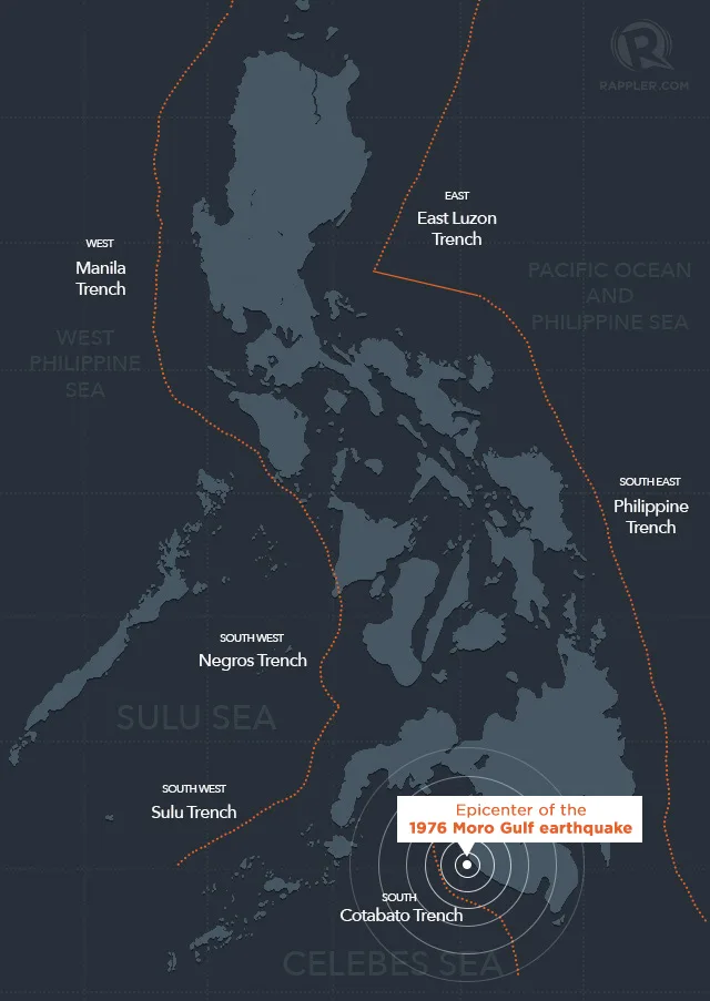
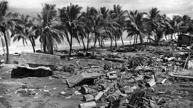
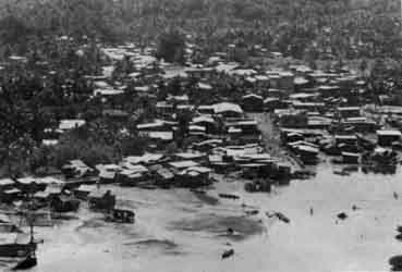
The August 1976 “Midnight Killer” tsunami took place off the Philippine island of Mindanao (8.4961° N, 123.3034° E) only a few minutes past midnight. The earthquake that initiated the tsunami is recorded as having reached a magnitude of 8.0 at its epicenter in the Moro Gulf. The earthquake and proceeding tsunami were felt all across the central islands of the Philippine Archipelago, as well as in the lower part of Luzon (Philippine Institute, 2018). This event injured an estimated 10,000 people and claimed about 8,000 lives (it is reported that 85% of deaths were the result of tsunami waves). Over 90,000 residents were displaced or homeless. A total of $134 million in damage to land and infrastructure was incurred (NOAA, ND).
The tsunami itself reached wave heights of nine meters and affected more than 700 kilometers of coastline. The places that felt these effects most were Mindanao, the Sulu Archipelago, and the Zamboanga Peninsula (although Zamboanga City was spared from serious damage and casualties due to the surrounding islands that acted as a natural barrier against the tsunami waves). In Cotabato City, Philipines, 1,500 residents died as a result of infrastructure collapses, including a college building and a two-story hotel (Bayce, 2022).
Discussion:
This event took place minutes after midnight, a time when most were in their beds asleep, completely unaware of the danger headed their way. Many woke up to the chaos confused and unprepared as to how to act. The last major tsunami that had taken place in the Philippines was in 1918, and so this community had no experience with a catastrophe such as this and was generally uneducated on the procedures to follow in the case of a disaster. Due to this inexperience and lack of education/preparedness, a tremendous amount of lives were lost. Many of the providences resided very close to shorelines, which also contributed to the extensive loss of lives and homes (The Associated Press, 2022). Since the catastrophe, many have rebuilt with the possibility of future events similar to the 1976 one in mind. The extent of the damage led the Philippine government to establish a National Disaster Coordinating Council, which would later be called the National Disaster Risk Reduction and Management Council (NDRRMC). In Bangsamoro, there was a push for local government units, such as the Incident Command System (ICS) and Rapid Emergency Action on Disaster Incidence (READi), in order to make communities more prepared and capable of reacting to disasters. Building codes were also updated in order to make them more durable to seismic activity, and siren systems were built to act as warnings.
Due to the Philippines being in a seismically active location, it is highly vulnerable to various types of natural disasters. Organized response groups like ICE and READi are crucial to mitigation and timely recovery. The “Midnight Killer” was a key event in the process of the Philippine government directing its attention and effort toward natural disaster education, preparedness, and responsiveness (Bangsamoro, 2022).
Many of those who survived the catastrophe are still around today, making the present population of Minandadao more experienced and prepared to face a similar event than they were before. Some report that warnings and advice are passed through generations in the form of survivors re-telling the horror of the “Midnight Killer” to children and grandchildren. Nearly all of the Mindanao coastal providences were destroyed, making this event one of the deadliest natural disasters the Philipines has ever endured. In an interview with WNYC, Philippine residents related the changes that have taken place as a result of the catastrophe. These changes include yearly drills, familiarizing the community with warnings such as the sound of incoming tsunami waves, siren systems, and the establishment and training of response groups such as ICE and READi. Modern Phillippines is much more prepared to face a catastrophe like that of 1976 than it ever has been in the past (The Associated Press, 2022).
Map of the Philippines showing the epicenter of the 1976 Moro Gulf earthquake that initiated the “Midnight Killer” tsunami and seismic trenches surrounding the Philippine Archipeligo.


