The Fork Ridge Fire started on September 12, 2024 in the Cherokee National Forest near Cleveland, Tennessee.
WVLT. "This Fire Was Lightning-Caused: Fork Ridge Fire Continues to Burn in Cherokee National Forest." WVLT News, 18 Sept. 2024, www.wvlt.tv/2024/09/18/this-fire-was-lightning-caused-fork-ridge-fire-continues-burn-cherokee-national-forest/. Description: This photo shows the ground and some trees on fire. I chose this image because it is relevant to this post.
The fire’s impact on the physical environment was significant. Vegetation loss increased the likelihood of soil erosion and disrupted ecosystems, forcing wildlife to relocate and reducing habitat availability. Long-term effects on the forest’s ecological balance, including changes in plant and animal populations, are expected. Smoke from the fire reduced air quality, affecting both the environment and the health of nearby residents (WVLT).
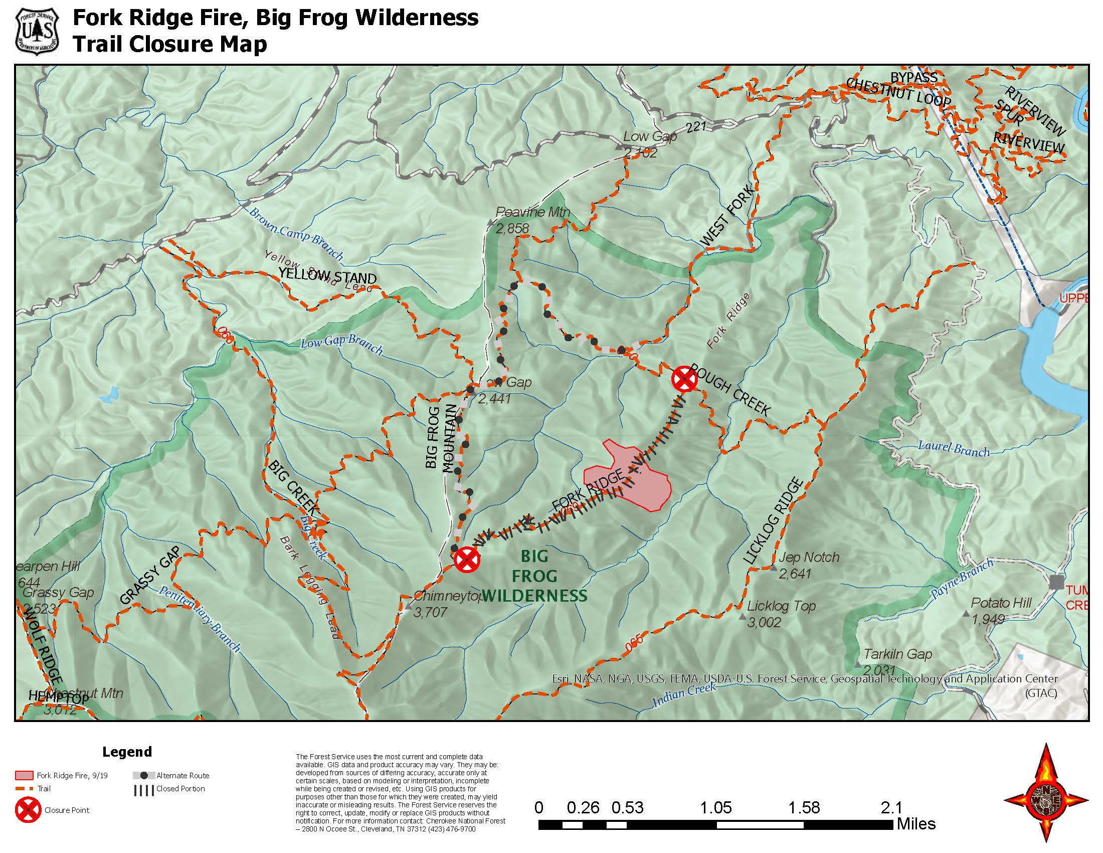
For the human environment, the fire caused several challenges. Local communities and visitors faced health risks from reduced air quality, especially those with respiratory conditions. Outdoor recreation, an important part of the region’s culture and economy, was temporarily halted, inconveniencing hikers and nature enthusiasts. The closures also emphasized the risks of wildfires in areas with high recreational use (U.S. Forest Service, "2024 Fork Ridge Fire").
While the Fork Ridge Fire was contained to a relatively small area, it highlighted the broader challenges of managing wildfires in remote, protected regions. It also underscored the importance of fire preparedness and mitigation strategies to protect both people and the environment in fire-prone areas. Efforts to recover and restore the forest, including ensuring safe trails for future visitors, will likely continue for years (InciWeb).

U.S. Forest Service. "2024 Fork Ridge Fire - Cherokee National Forest." InciWeb, U.S. Department of Agriculture, 2024, inciweb.wildfire.gov/incident-information/tncnf-2024-fork-ridge-fire-cnf. Description: This map shows the trails that were closed in response to the fire. I chose this image because it is relevant to this post.
The Fork Ridge Fire serves as a reminder of the significant risks posed by wildfires in vulnerable areas, especially within national forests and wilderness regions. While such fires are a natural part of many ecosystems, the growing intensity and frequency of these events have raised concerns about their long-term consequences for both the physical and human environment. In this case, the fire caused vegetation loss, potentially leading to soil erosion and disrupting wildlife habitats. Additionally, smoke pollution affected local air quality, posing health risks to nearby communities (Gainesville).
One of the key implications of this fire is the impact on local ecosystems. Fires can have long term effects on plant and animal populations, particularly in sensitive wilderness areas where recovery can take decades. The loss of vegetation not only affects the food chain but also disrupts the carbon and water cycles that are crucial for maintaining forest health. Furthermore, the fire highlighted the vulnerability of popular recreational areas. When trails are closed and access is limited, the economic and social benefits tied to outdoor activities are temporarily lost, affecting tourism and local economies (WVLT).
To mitigate such impacts, several strategies could have been employed. First, controlled burns or prescribed fires could have been used in the area prior to the fire season to reduce the amount of fuel available, potentially preventing a fire from growing as large and destructive. Forest management techniques, such as thinning dense tree stands and clearing dead wood, could also have helped lower fire intensity. Additionally, public awareness campaigns could educate hikers and visitors about fire risks and the importance of following fire safety guidelines, reducing human-caused ignition sources (U.S. Forest Service, "Cherokee National Forest Trail").
Another critical aspect of fire mitigation is early detection and rapid response. Improved monitoring technology, such as drones or satellite systems, could assist in detecting small fires before they spread uncontrollably. Collaboration between fire management teams, local authorities, and residents can also enhance preparedness and ensure effective evacuation plans if necessary. Finally, addressing climate change by promoting policies to reduce carbon emissions may help decrease the extreme weather patterns that exacerbate wildfire conditions (Gainesville).
While the Fork Ridge Fire is a natural occurrence in some aspects, the growing frequency of such fires and their widespread consequences call for enhanced preventive measures, community involvement, and a shift toward proactive fire management to protect both the environment and human populations (InciWeb).

Gainesville. "Fork Ridge Fire." Gainesville Fire Data, 2024, data.gainesville.com/fires/fork-ridge/7146ca8b-76b0-4ce5-886a-96aedd83d823/. Description: This photo shows a hillside on fire during the Fork Ride Fire. I chose it because it is a photo of the fire this post is about.
Video: https://www.wvlt.tv/video/2024/09/18/fork-ridge-fire-continues-burn-cherokee-national-forest/
Description: This video is of a news report of the fire. Several people are shown discussing the fire.
Sources
U.S. Forest Service. "Cherokee National Forest Trail to Close Due to Wildfire." U.S. Department of Agriculture, 14 Sept. 2024, www.fs.usda.gov/detail/cherokee/news-events/?cid=FSEPRD1205450
Gainesville. "Fork Ridge Fire." Gainesville Fire Data, 2024, data.gainesville.com/fires/fork-ridge/7146ca8b-76b0-4ce5-886a-96aedd83d823/
U.S. Forest Service. "2024 Fork Ridge Fire - Cherokee National Forest." InciWeb, U.S. Department of Agriculture, 2024, inciweb.wildfire.gov/incident-information/tncnf-2024-fork-ridge-fire-cnf
WVLT. "This Fire Was Lightning-Caused: Fork Ridge Fire Continues to Burn in Cherokee National Forest." WVLT News, 18 Sept. 2024, www.wvlt.tv/2024/09/18/this-fire-was-lightning-caused-fork-ridge-fire-continues-burn-cherokee-national-forest/