The Yellowstone Fires of 1988
 |
| Jeff Henry/National Park Service; Shows the destructive impact of the 1988 fires |
|
| Jeff Henry/National Park Service; Shows the destructive impact of the 1988 fires |

So when talking about wildfire I know we all think about California and Australia and that's for good reasons. But do you ever think about fires in Europe let alone even Italy? Well, it's true, they really do happen and the most recent one happened in 2017. In the mid-month of July, 11 some of the biggest fires in Italy's recent history broke out. This fire stretched from the regions including Naples, and Sicily, and Basilicata. (The states of Campania; Basilicata; and Sicily)(3). Firefighters in Italy intervened in more than 10,000 individual vegetation fires, These fires majority affected the southern parts of Italy including the previously mentioned regions. (1)
-----------------------------------------------------------------------------------------------------------------------------

(Map and satellite view of southern Italy) (1)
Officials have reported nearly 900 wildfires in Italy (5). With people having to evacuate from their homes, businesses, and livelihoods. These fires raged on for days and burned done fast territory of the Castelfusano pine forest near the coast of the south of Rome. Fires have also even started to ravage the national park on Vesuvius one of the most infamous volcanos in the world. These major fires are believed to have their origins in human activities. However, Italy has been suffering from extensive heat and lengthy drought. So even if humans are the cause it was intensive due to the effects of global warming. The economic damage is harder to find due to a lack of government support and funding. But there are some educators on how much these fires cost the country- - And sadly there are reports of death as well, One instant was that of a 79-year-old woman who was found dead in a filed. close to her home in Sant'Omero, She was overcome by flames that engulfed two hectares of surrounding farmland (7) In June, Sicily saw 40 percent less rainfall and temperatures were up by 1.7 celsius compared to that of the average for the month. Paired with the strong winds and arid conditions helped fuel the fires to be able to rage for 3 days. (1)

(This is a fire on the side of Mount Vesuvius)(5)
-----------------------------------------------------------------------------------------------------------------------------
Economic loss & mitigation
The fires were able to take care of after only 3 days.(2) But this highlights the effects of climate change on this very economically strained region. Estimates on climate show a very significant change in magnitude and duration of extreme water conditions onward since the 1970s indicates a shift in the hydrological process (6). This article's main point was to talk about the effects of climate change and fishers, but we are able to use the date that was found and applied it to the increase of wildfires in the region.


(1) Jenner, L. (2017, July 03). Fires on Sicily and Southern Italy. Retrieved December 12, 2020, from https://www.nasa.gov/image-feature/goddard/2017/fires-in-sicily-and-southern-italy
(2) Southern Italy struck by wildfire. (n.d.). Retrieved December 12, 2020, from https://www.bbc.com/news/av/world-europe-40591756
(3) Wildfires rage in southern Italy, Vesuvius slopes. (2017, July 11). Retrieved December 12, 2020, from https://apnews.com/article/f1f1809c776e4cf7a2cf97c2dc8715eb
(4) By:, P. (2017, July 12). Wildfires Rage in Southern Italy. Retrieved December 12, 2020, from https://wildlandfirefighter.com/2017/07/12/wildfires-rage-in-southern-italy/
(5) -, S., By, -, Strange Soundshttps://strangesounds.orgFollow Strange Sounds to discover amazing, Strange Sounds, & Follow Strange Sounds to discover amazing. (2017, July 19). European Inferno: Large wildfires burn hundreds of hectares across France, Croatia, Italy, Portugal, Montenegro. Retrieved December 12, 2020, from https://strangesounds.org/2017/07/large-wildfires-burn-hundreds-of-hectares-across-france-croatia-italy-montenegro-european-inferno.html
(6) Nicola, G., Elvira, B., Jonsson, B., Ayllón, D., & Almodóvar, A. (2017, November 06). Local and global climatic drivers of Atlantic salmon decline in southern Europe. Retrieved December 12, 2020, from https://www.sciencedirect.com/science/article/abs/pii/S0165783617302874
(7) Staff, S. (2017, August 03). Italy heatwave and drought spark killer wildfires. Retrieved December 12, 2020, from https://phys.org/news/2017-08-italy-heatwave-drought-killer-wildfires.html
(8) N. (n.d.). Retrieved December 11, 2020, from https://www.nifc.gov/fireInfo/fireInfo_documents/SuppCosts.pdf
(9) Bottinelli, S. (2017, July 13). 600 Tourists rescued by boat as wildfires engulf Calampiso resort in Sicily. Retrieved December 12, 2020, from https://www.ybw.com/news-from-yachting-boating-world/600-tourists-rescued-by-boat-as-wildfires-engulf-town-of-calampiso-in-sicily-56400
(10) Why Italy's economy is about to collapse. (2016, June 20). Retrieved December 12, 2020, from https://www.independent.co.uk/voices/why-italy-s-economy-about-collapse-a7091221.html
 |
| Figure 1. The aftermath of the hurricane that hit Galveston, Tx. A large portion of the buildings impacted by the storm were in residential areas of Galveston which, contributed to the overall death toll of the hurricane. (Source- https://www.census.gov/history/www/homepage_archive/2015/september_2015.html) |
 | ||
| Figure 2. The path and intensity levels at different locations of the 1900 Galveston hurricane. Galveston received the most intensity, and damage out of all the areas the hurricane impacted. (Source- https://celebrating200years.noaa.gov/magazine/galv_hurricane/galveston_1900_map.html)
Before the creation of massive satellites which could detect the early formation of hurricanes, the primary way for meteorologists to predict if a hurricane was going to occur was word of mouth. What this means is the ships that were out in the coast would electrically telegraph any weird or abnormal winds back to the meteorologist on shore, this allowed for the scientist to make predictions on when or if possible storms would occur (Waxman 2017). This system was very inaccurate and is part of the reason that this hurricane was so detrimental. When early storm reports were recorded close to Cuba (Figure 2.) from ships, the Weather Bureau released a storm warning on September 7th, 1900 (Waxman 2017). These warnings failed to inform people in Galveston because it was only classified as a storm not a hurricane.
|
CAMP FIRE- 2018 CALIFORNIA WILDFIRES
1) The
Camp Fire Wildfire in Butte County, Northern California started on 8 November,
2018, and was 100 % contained seventeen days later on 25 November, 2018.(census.gov)

Camp Fire is now deadliest in
California history- CNN.com
2) The
Camp Fire in Butte County, California, was named for the area it started in
which is Camp Creek Road. It is the most disastrous and lethal wildfire in
California’s history. It is toward the top of the list for the world’s
deadliest wildfires, and it ranks 6th deadliest in United States
history. This enormous fire was caused by electrical transmission lines owed by
Pacific Gas and Electricity located in the area of Pulga(fire.ca.gov). CAL FIRE
investigators thoroughly investigated the area of the fire’s origin to
determine cause. The fire started early in the morning of the 8th of
November near the community of Pulga in the county of Butte. With Red Flag
conditions in place, strong winds blowing, very dry vegetation and tinder, high
temps, and low humidity stimulated the wildfire and caused it to spread
exceptionally fast. The fire burned 153,336 acres, destroyed 18,804 structures,
and it is responsible for the evacuation of 52,000 people, caused 85 civilian
deaths, and injuries to several firefighters. It was determined that most of
the damage occurred in the first four hours of the wildfire. As the first
winter rains appeared, firefighters achieved 100 percent containment of the
Camp Fire Wildfire seventeen days later on the 25th of November.

CAMP FIRE DESTROYS PARADISE,
CALIFORNIA: PHOTOS-THE ATLANTIC
Creator: JOSH
EDELSON | Credit: AFP/Getty Images
3) The
actions that could have mitigated the Camp Fire in California are many.
Firstly, it was determined that Pacific Gas and Electricity has equipment that
was sparking or malfunctioning. PG&E is a California state regulated
electric company. Another possible mitigation is forest management.CAL FIRE,
the main firefighting agency in the state, stated that decades of policy that
discouraged controlled burns to reduce the fuel load. Some prescribed burns in
the state have been hindered by the concerns for air quality and by
environmental lawsuits(Forbes.com). Nearly half of California’s land is
government owned and managed by the U.S. Forest Service. Before 1990,
approximately 10-12 billion board-feet of timber was harvested from national
forests. In 2013, due to environmental policies, only 2.5 billion board-feet
was harvested. It is not difficult to see that there would be much larger
underbrush and timber available to fuel bigger wildfires. Another contributing
factor could be the rising prices of real estate in California’s cities. With
high priced real estate, and even higher taxes many people are moving outside
the city limits where they can afford a bigger house or acquire some land at a
lesser price than in the city. This savings in property and taxes makes a
commute into work well worth the time it takes to drive back and forth. With so
many wildfires taking place in the summer months, when the rains come in the
winter season, flooding is promoted by the lack of vegetation on the hillsides
in California. One way to mitigate the damage is to build houses and other
structures with fire resistant materials that can better withstand fires.

Understory burn as part of the Red
Salmon Complex Fire, September 3, 2020.
United States Forest Service via
Wikimedia Commons.
The link below shows a small part
of the devastation of Camp Fire Wildfire 2018.
https://www.youtube.com/watch?v=o2KACRDzG14
https://www.census.gov/topics/preparedness/events/wildfires/camp.html
https://www.fire.ca.gov/media/5121/campfire_cause.pdf
Eremita, Brianna;
Komshian, Karin; and Leza, Sedona, "Fire-Resilient Housing for Paradise,
California" (2019). Civil,
Environmental and Sustainable Engineering Senior Theses. 76.
https://scholarcommons.scu.edu/ceng_senior/76
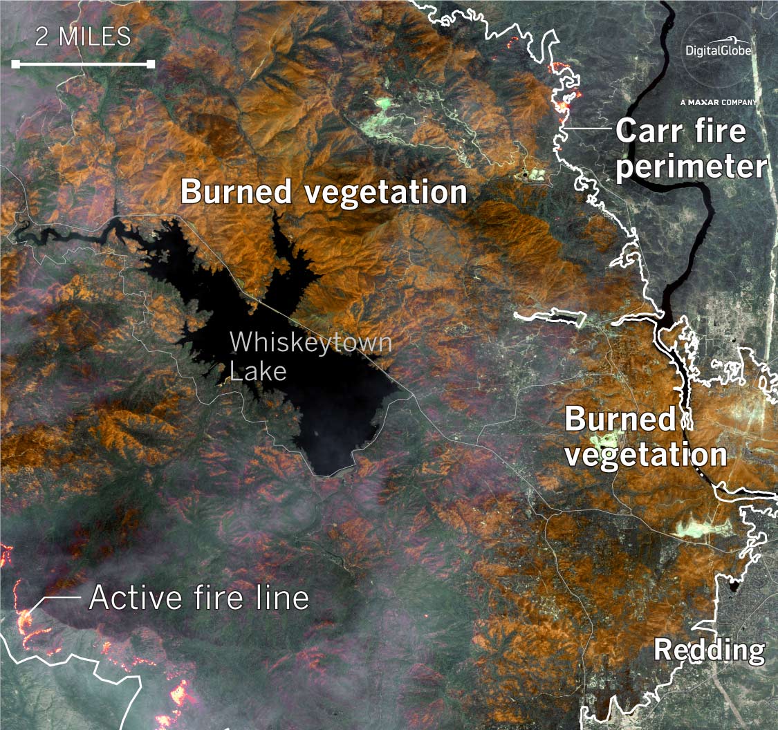 |
| Satellite imagery of the extent of the Carr Fire. Source. |
:format(webp):no_upscale()/cdn.vox-cdn.com/uploads/chorus_asset/file/11903333/GettyImages_1008050668.jpg) |
| Part of the Carr Fire, July 30th, 2018. Source. |
 |
| Homes destroyed by the Carr Fire in Redding, California. Source. |

Hurricane Maria began as a tropical wave that left the African west coast in September of 2017. As the system moved through the Atlantic, it produced deep convection beneath the ocean’s surface. This convection quickly became less scattered and more organized. Upon moving into an area of mid-level pressure, this system grew to be a tropical storm. With the introduction of warm water to the system, it very rapidly morphed into a hurricane that also strengthened swiftly (Pasch, et al., 2017). This hurricane would wreak havoc throughout its path. One of the most significantly affected areas is Puerto Rico, where Hurricane Maria is known as “the worst storm to hit the island in nearly a century” (Rivera & Rolke, 2018). When Maria made contact with Puerto Rico windspeeds were approximately 155 miles per hour, and brought in over a foot of rainfall, resulting in massive flooding. Many residents were without power, fresh water, or means of communication. Rivera and Rolke (2018), identified the elderly as a population with increased vulnerability, in regards to Hurricane Maria. This is because many of them were effectively disconnected from lifesaving aid. Three months post-hurricane, Puerto Rico had only been able to restore approximately 68% of the power grid that had been available before the storm (Rivera & Rolke, 2018). The exact death toll remains a topic of controversy. However, a published study from Harvard estimated that 4,645 deaths can be attributed to Hurricane Maria and the “immediate aftermath” it presented (Hernandez & McGinley, 2018).


Sources
Hernandez, Arelis R., and Laurie McGinley. “Harvard Study Estimates Thousands Died in Puerto Rico Because of Hurricane Maria.” The Washington Post, WP Company, 29 May 2018, 3:15 p.m., www.washingtonpost.com/national/harvard-study-estimates-thousands-died-in-puerto-rico-due-to-hurricane-maria/2018/05/29/1a82503a-6070-11e8-a4a4-c070ef53f315_story.html.
“Hurricane Maria.” Encyclopedia Britannica, Encyclopedia Britannica, Inc., www.britannica.com/event/Hurricane-Maria.
Pasch, Richard J., et al. “Hurricane Maria.” National Hurricane Center Tropical Cyclone Report, Sept. 2017, www.nhc.noaa.gov/data/tcr/AL152017_Maria.pdf.
Rivera, Roberto, and Wolfgang Rolke. “Estimating the Death Toll of Hurricane Maria.” Royal Statistical Society, John Wiley & Sons, Ltd, 6 Feb. 2018, rss.onlinelibrary.wiley.com/doi/full/10.1111/j.1740-9713.2018.01102.x.
Rodríguez-Díaz, Carlos E. "Maria in Puerto Rico: natural disaster in a colonial archipelago." (2018): 30-32.
Segarra, Lisa Marie, and Kim Bubello. “Scenes of the Destruction From Hurricane Maria.” Time, Time Magazine, time.com/hurricane-maria-destruction-photos/.
MT.
ST. HELENS VOLCANIC ERUPTION MAY 1980
1) A
volcanic eruption occurred on Mt. St. Helens in Washington State’s Cascade
mountain range on May 18, 1980.

2) On
the morning of 18 May, 1980, a 5+ earthquake initiated the eruption of Mt. St.
Helens, which in turn caused the northern flank of the mountain to collapse.
The largest landslide in recorded history buried 14 miles of the North Fork
Toutle River with trees, rocks, and earth averaging 150 feet deep. Some places
were recorded as deep as 600 feet of debris. The powerful blast blew down over
4 billion board-feet of timber, and spread volcanic debris over 230 square
miles. On the southern half of the mountain, lahars(mudflows) flowed down
through gullies and rivers. The blast, volcanic avalanche, and Lahars caused
extensive damage to the human environment as well as the physical environment.
All manmade structures within the locality of Spirit Lake were completely
buried. Over 200 houses and cabins were destroyed along with recreational
sites, roads, bridges, and trails. Fifeteen miles of railroad tracks, and
approximately 185 miles of paved roads highways were damaged or completely
destroyed. Fifty seven people lost their
lives from the volcanic eruption, mostly from asphyxiation from inhaling hot
volcanic ash, and some of the victims died from thermal and other injuries
according to autopsies. The Washington State Department of game estimated that 7,000
bear, elk, and deer perished in the immediate affected area, as well as all
birds and a majority of smaller mammals. The Washington Department of Fisheries
estimated that 12 salmon fingerlings were killed, which could have produced
nearly 360,000 adult Chinook and Coho salmon.
Downwind from the volcano, many
crops were destroyed such as alfalfa, wheat, potatoes, and apples.

Stand of timber in the "tree-down" zone north of
Mount St. Helens devastated by the lateral blast. The downed trees were
salvaged as quickly as possible before the wood began to rot. Note the two
people (circled) in lower right (Photograph by Lyn Topinka).
3) The
importance of the Mt. St. Helens eruption cannot be understated by today’s
volcanologists. That single eruption did more than any other volcanic eruption
in history since it was the first large explosion to be studied by scientists.
That in turn led to advances in volcano science. New and advanced monitoring
systems were invented due to Mt. St. Helens being easily accessible and could
be recorded and photographed from many angles. The open cone also has let
scientists peak inside the volcano and understand more about the mountain than
ever before. Scientists from all over the world joined together to study the
eruption. Before Mt. St. Helens, most scientific fields in the study of
volcanoes worked separately and there was little coordination. Now 40 years
later it is typical for biologists, geologists, hydrologists, seismologists,
geochemists, and geophysicists to coordinate and combine their studies of
natural science processes into a unified research and communication. The
science of volcanoes has gone from a few monitoring pieces of equipment at the
source of the volcano, to using GIS, LIDAR, satellite images, and
photogrammetry. These advances in technology can now detect inflation and
deflation of volcanoes down to the centimeter in real time. Using these
advanced systems, scientists are starting to develop advanced warning systems
around the globe to detect future eruptions. With the technology in 1980, and
few volcanoes being studied with modern equipment, most experts agree that
little more could have been done to mitigate the impacts of the eruption at Mt.
St. Helens. It is BECAUSE of the eruption at Mt. St. Helens that scientists
know what they now know and can try to minimize the risk to the public for
future volcanic eruptions around the globe.
Forty years after the blast: next generation
continues Mt. St. Helens research
News.wsu.edu
The link to the video
below depicts illustrations from today’s scientists, with modern technology,
explaining the cause of devastation of the 1980 eruption of Mt. St. Helens.
Included in the 4 ½ minute video is actual footage of the eruption as it is taking
place.
https://www.youtube.com/watch?v=AYla6q3is6w
SOURCES
https://www.usgs.gov/news/mount-st-helens-1980-eruption-changed-future-volcanology
https://earthobservatory.nasa.gov/world-of-change/StHelens
http://vulcan.wr.usgs.gov/Volcanoes/MSH/Publications/FS036-00/framework.html
https://pubs.usgs.gov/gip/msh/impact.html https://www.cnn.com/2013/07/26/us/mount-st-helens-fast-facts/index.html
https://www.cnn.com/2013/07/26/us/mount-st-helens-fast-facts/index.html
https://www.history.com/topics/natural-disasters-and-environment/mount-st-helens
 |
| Figure 1. Hurricane Harvey rainfall. Source: National Weather Service |
 |
| Figure 2. Flooded house during Hurricane Harvey. Source: Wall Street Journal |
 |
| Figure 3. Initial unemployment claims for the Great Recession and Hurricane Harvey. Source: Houston Chronicle |
Works Cited
Amadeo, Kimberly. "Hurricane Harvey Shows How Climate Change Can Impact
the Economy." The Balance, 24 September, 2020, https://www.thebalance.com/hurricane-harvey-
facts-damage-costs-4150087.
Blake, Eric S. & Zelinsky, David A. "Tropical Cyclone Report: Hurricane Harvey." National Hurricane
Center, 9 May, 2018, https://www.nhc.noaa.gov/data/tcr/AL092017_Harvey.pdf.
Heft, Jayleen R. "The Untold Story of Hurricane Harvey Wind Damage: 12 Key Findings." Property
Casualty 360, 10 September, 2018, https://www.propertycasualty360.com/2018/09/10/the-untold-
story-of-hurricane-harvey-wind-damage-1/?slreturn=20201110164211.
Mutikani, Lucia. "Hurricane Harvey Boosts U.S. Jobless Claims to More than Two-Year High."Reuters, 7
September, 2017, https://www.reuters.com/article/us-usa-economy/hurricane-harvey-boosts-u-s-
jobless-claims-to-more-than-two-year-high-idUSKCN1BI1MV.
Oldenborgh, Geert J. V., Karin V. D. Wiel, Antonia Sebastian, Roop Singh, Julie Arrighi, Friederike Otto,
Karsten Haustein, Sihan Li, Gabriel Vecchi & Heidi Cullen. "Attribution of Extreme Rainfall for
Hurricane Harvey, August 2017." Environmental Research Letters 12, no. 12, 13 December, 2017,
https://iopscience.iop.org/article/10.1088/1748-9326/aa9ef2?dom=AOL&src=syn.
"The Impact of Hurricane Harvey." University of Houston, 24 August, 2020, https://uh.edu/hobby/harvey/
