Featured Post

Welcome to the Blog

Welcome to our Natural Disasters Blog!  Below you will post your disaster summaries as you complete them. Remember to initiate a post with t...

Wednesday, September 14, 2022

The Shaanxi Earthquake of 1556

Figure 1: Depicts approximate epicenter and surrounding provinces. 

Shaanxi Earthquake of 1556

Introduction

On January 23, 1556, Chinese civilians awoke and began what they thought to be another regular day, completely unaware of the pressures building up beneath them. That morning, an unforeseeable natural disaster would occur, now widely known as the Shaanxi Earthquake. The epicenter occurred in the Wei River valley, located in close proximity to a few cities such as Huaxian, Weinan, and Huayin. Unfortunately, these cities would not be the only victims of such tragedy. While it only lasted a few seconds, the earthquake shook with immense power, spreading across 520 miles and affecting almost 100 nearby countries. (Harris, 2008) "Although the region had reportedly suffered multiple powerful earthquakes before — 26 others were noted in local reports — this rather unknown yet tragic quake was unlike any that came before it or since." (Littlechild, 2021)


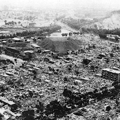
Figure 2: Reveals significant damage
near the epicenter.

Environmental Effects

The earthquake shook with incredible force, obliterating  everything in its path for 520 miles. In modern terms, it would  have ranked an 8 on the Richter scale. Not only did the earthquake wreak havoc along the surface, but it also changed landforms and functions of nature. For instance, the ground tore open, creating crevices up to 66 feet deep. The formation of new hills and valleys encompassed the land, while certain streams and rivers shifted their flow in the opposite direction. Multiple fires raged across the land as well. (Littlechild, 2021) One can only imagine the horrific impact this occurrence had on the environment, humankind, wildlife, and so on. 830,000 people were killed during this disaster, which is over 60% of the population in that area. (Harris, 2008) There were high-scale societal impacts as well that would change the course of the future drastically. In the city of Huaxian, every piece of infrastructure would be demolished, leaving behind no hope or possibility of recovery. At the time, ‘residential’ areas consisted of yaodongs, caves carved into the hillside of the Loess plateau region. The severity of the earthquake would cause these homes to completely collapse, leaving thousands of civilians to be buried alive. Typically, artifacts and treasures are left behind after a large group of people pass, however, even these historical pieces would be tarnished or destroyed. For example, an important cultural form of architecture, known as The Small Wild Goose Pagoda, would lose almost six feet of height. Another popular building, China’s Stele Forest Museum, housed plentiful records, statues, artifacts, and engravings. The Tang Stone Classic collection would be ruptured and illegible. (Elhassan, 2018) With this information in mind, there would be no way to accurately calculate the true impact of environmental and economic damage at this early chapter in time. However, some might compare the damage costs to "the detonation of a nuclear weapon." (Uaecraga, 1970)

Figure 3: A visual illustration of the various
plates involved in the Shaanxi Earthquake.

Importance of Disaster

The Shaanxi Earthquake of 1556 would ensue lasting effects on both the environment and those who survived. Though this became known as one of the most disastrous earthquakes in history, its existence would fuel a new generation of knowledge and understanding. One surviving scholar by the name of Chin Qeda would later search for details to gain insight on hazards and deadly events. His goal was to establish measures of safety and prevention. He would have to analyze the probability of this event happening again, the exposure it would have, and the idea of potential vulnerabilities. One recorded quote of Chin Qeda’s is as follows, at the very beginning of an earthquake, people indoors should not go out immediately. Just crouch down and wait. Even if the nest has collapsed, some eggs may remain intact“. (Elhassan, 2018) This idea is an early sign of safety acknowledgement and demonstrates a procedure many of us are familiar with still today. Another way to interpret vulnerability is to be aware of environmental patterns, landforms, sediment types, etc.. As mentioned previously, many civilizations in China grew to prosper in Loess regions, where the soil tends to be rich and silt-like. This kind of soil is easily disturbed by vibrations, especially those with a magnitude as high as the Shaanxi earthquake. This type of land made farming significantly easier and more productive when compared to other forms of soil. The combination of rich agriculture and favorable climates led to an obvious boom in population. At the time, no one was particularly aware of every variation of natural hazards, so they fell into a swirl of oblivion when disaster struck. Later on, it would be known that this portion of China lies directly above the Amurian Plate and in conjunction with three others: the North American Plate, the Philippine Plate, and the Indian Plate. When these plates converge, the crust warps and creates pressure and impact. “The Loess Region, and Shaanxi province, in particular, are susceptible to warping from those tectonic plate pressures.” (Elhassan, 2018) While humans were not yet aware of the logistics of plate tectonics and the like, they remained aware and began to create sturdier infrastructure. Unfortunately, nothing could have prepared the civilizations of China for this major natural event. There was no technology to understand the important properties of earthquakes, tsunamis, or even landslides. The most important piece the survivors could take away from this experience would be to take caution, warn others, and take preventative action (such as utilizing other resources for infrastructure.) 

This video illustrates concepts and ideas regarding the Shaanxi Earthquake of 1556. It briefly describes the impact of the disaster, the cause, and lasting effects on Chinese society.

Sources Cited:

Littlechild, C. (2021, July 27). The Deadliest Earthquake in History That No One Talks About. Grunge.com. Retrieved September 14, 2022, from https://www.grunge.com/470761/the-deadliest-earthquake-in-history-that-no-one-talks-about/

Elhassan, K. (2018, October 13). Deadliest earthquake in Shaanxi Province: 1556 Shaanxi earthquake. History Collection. Retrieved September 13, 2022, from https://historycollection.com/historys-deadliest-earthquake-in-shaanxi-1556-leveled-mountains-and-reversed-rivers/3/

Harris, C. (2008, May 12). Shaanxi earthquake. World History Project. Retrieved September 13, 2022, from https://worldhistoryproject.org/1556/1/23/shaanxi-earthquake

Shaanxi earthquake – China – 1556 AD. Devastating Disasters. (n.d.). Retrieved September 13, 2022, from https://devastatingdisasters.com/shaanxi-earthquake-china-1556-ad/

Uaecraga. (1970, January 1). 1556 Shaanxi earthquake. Retrieved September 14, 2022, from https://mycookbookaddiction.blogspot.com/2008/10/1556-shaanxi-earthquake.html

Figure 1: https://worldhistoryproject.org/1556/1/23/shaanxi-earthquake
Figure 2: https://i.pinimg.com/736x/bf/45/d0/bf45d0bc8e59a4d554c40b4fa2a665b4.jpg
Figure 3: https://i.pinimg.com/originals/4b/60/e1/4b60e1aa1d6783627b1ada3f4bf316a1.png


Izmit 1999 Earthquake:


Map of northwestern Turkey depicting the fault lines running between the Anatolian Block and the Eurasian Plate and the location of the epicentre of the İzmit earthquake of Aug. 17, 1999. (Encyclopedia Britannica, Inc, n.d.)


            At around 3 am local time on the 17th of August 1999, northwestern Turkey was struck by an earthquake with a magnitude of 7.4 (Gillies et al., 2001). It occurred on the northernmost strand of the Northern Anatolian fault system with an initial shock that lasted less than a minute. It was then followed by two smaller aftershocks on August 19th (USGS, 2022). 

The main regions affected by this earthquake were the densely populated cities of Izmit and Adapazari, which are located in the provinces of Kocaeli and Sakarya. This was mainly due to the epicentre being located about 11km southeast of Izmit. These afflicted regions were Turkey’s industrial core, with Istanbul and nearby provinces accounting for approximately one-third of the nation’s total output (Bibbee et al., 2000).

There were many impacts caused by the initial earthquake. Many apartment buildings entirely collapsed, killing a large number of individuals who had been asleep when the earthquake struck. It took five and a half days to control and put out a fire in the Tupras oil refiners, which at the time processed 86% of Turkey’s oil. The fire had threatened to spread to neighbouring industrial facilities. Surface breaks cut into the toe of the fan delta where the town of Degirmendere was located at the western end of the rapture zone. This resulted in a slump, 100m normal to the coastline. Parts of Degimendere slid under water, including a hotel as well as several stores and restaurants. The severity, scope, and loss of life during the first two days were vastly underestimated. (Barka, 1999)

At least 17,118 people were killed, close to 50,000 were wounded, about 600,000 were left homeless, and the damage ranged from 3 to 6.5 billion USD in the provinces of Kocaeli and Sakarya, and Instanbul. (USGS, 2022).

In the past, Turkish builders employed conventional, time-tested construction techniques to reduce damage from earthquakes. However, rapid growth in population in the early 1980s changed this (Gillies et al., 2001) and the earthquake exposed several flaws in urban design and construction methods that had increased the infrastructure and death toll of the disaster:

Large-scale urbanisation had been approved where liquefiable soil was present. Because the majority of the impacted infrastructure was less than twenty years old, the horrific death toll resulting from poor foundation systems – one of the main causes of destruction in Adapazari – is all the more tragic. 

Problems with construction engineering were a significant additional cause of the catastrophe. Most collapsed multi-story buildings had weak ground floor levels due to their use for commercial purposes, with fewer retaining walls and higher ceilings, which led to ground floor collapses. The widespread usage of hollow clay tiles that are not reinforced to build interior and exterior walls had a negative impact on how well the structural frame performed during the earthquake. (Bibbee et al., 2000).


Buildings damaged by the İzmit earthquake in Turkey, 1999 (Encyclopedia Britannica, Inc, n.d.)


The challenges in mounting a prompt and efficient official emergency response to the earthquake may have contributed to the significant loss of human life. This was mostly because it happened at 3 am with many of the emergency response officials among those who were trapped inside the collapsed buildings. As well as this the majority of the emergency response equipment was destroyed or damaged. (Bibbee et al., 2000).

Poor communication and significant damage to the main route linking Istanbul and Ankara lead to further delays in rescue efforts. It was further exacerbated by people blocking other routes when attempting to reach family and friends in the worst-affected areas (Barka, 1999).  Over 600 000 individuals were forced to seek emergency shelter as a result of the earthquake's damage to or destruction of over more than 300 000 dwelling units. The government made the early decision that stronger temporary housing have to be used in place of tents due to the impending cold and wet winter weather. (Bibbee et al., 2000). Private contractors were criticised heavily for their work and for utilising cheap, subpar materials as the majority of the fatalities were caused by the collapse of residential buildings. Although several contractors were criminally charged, relatively few of them were convicted. The public chastised officials for not enforcing building regulations about earthquake-resistant designs. (Tikkanen., 2022).


Video: https://www.youtube.com/watch?v=T0VV_JOmNps


References:

Barka, A., 1999. The 17 August 1999 Izmit earthquake. Science, 285(5435), pp.1858–1859.

Bibbee, A. et al., 2000. Economic effects of the 1999 Turkish earthquakes. OECD Economics Department Working Papers.

Earthquake.usgs.gov. 2022. [online] Available at: <https://earthquake.usgs.gov/earthquakes/eventpage/usp0009d4z/executive> [Accessed 10 September 2022].

Encyclopedia Britannica, Inc, n.d. Map of northwestern Turkey depicting the location of the epicentre of the İzmit earthquake of Aug. 17, 1999.. [image] Available at: <https://www.britannica.com/event/Izmit-earthquake-of-1999> [Accessed 12 September 2022].

Gillies, A., Anderson, D., Mitchell, D., Tinawi, R., Saatcioglu, M., Gardner, N. and Ghoborah, A., 2001. The August 17, 1999, Kocaeli (Turkey) earthquake — lifelines and preparedness. Canadian Journal of Civil Engineering, 28(6), pp.881-890.

Tikkanen., A., 2022. İzmit earthquake of 1999 | Turkey. [online] Encyclopedia Britannica. Available at: <https://www.britannica.com/event/Izmit-earthquake-of-1999> [Accessed 10 September 2022].

U.S Geological Survey, n.d. İzmit earthquake of 1999. [image] Available at: <https://www.britannica.com/event/Izmit-earthquake-of-1999> [Accessed 12 September 2022].

Tuesday, September 13, 2022

 2005 Kashmir Earthquake

                Shortly after 8:50 am on October 5, 2005, in the Kashmir region of Pakistan, a magnitude 7.6 earthquake shook the region. The epicenter of said earthquake was about 12 miles to the northeast of the Pakistani capital of Kashmir Muzaffarabad, located at 34.493 degrees North and 73.629 degrees East, with a focal depth of 26 km (History 2009). Kashmir is located right on the boundary of the Eurasian Plate and the Indian plate. These plates are in collision with each other, with the Indian plate being forced under the Eurasian Plate, creating one of the most active fault zones in the world. In the case of the 2005 earthquake, a shallow fault caused a rupture stretching 75 km (Naranjo 2008). This rupture caused shaking which was felt as far as Northern India and Afghanistan. The quake was one of the most damaging and deadly natural disasters that the region has faced in recent history with and estimated 80,000 people killed, and more than twice that injured. The quake also left more than 4 million people homeless just before winter (EERI 2005). In addition to the initial shaking and damages of the quake, there were continued landslides and fissures in the earth, causing immeasurable damages throughout the region. 

                    The impact this earthquake had on the city of Muzaffarabad and the surrounding region were devastating. The death toll was one of the most deadly earthquakes not only in the region, but in the world, with a death toll of around 80,000 people. In addition to this, about 200,000 people were injured and millions displaced. This would be bad enough alone, but the disaster occurred right before winter, exacerbating the effects. Response to the disaster were enacted as quickly as possible by the local army, who while suffering damages themselves, still attempted to provide relief to those in need in the form of food, medicine and shelter. Rescue operations were launched throughout the region as well, in an attempt to save many of those buried in the rubble. Though relief was as swift as it could be with field hospitals set up almost immediately after the incident and helicopters delivering supplies, many of the operations were hindered due to the many landslides following the event. These landslides wiped out roads throughout the region, making it difficult to travel both on foot and in an automobile, with the main mode of relief transportation being helicopters. This particular earthquake was not only devastating to the people, but also the structures and infrastructure of the area. Most of the buildings in the city of Muzaffarabad were not built to withstand earthquakes, many of them being unreinforced stone houses with weak trusses and random building materials. These older stone buildings were reduced to rubble in the aftermath of the quake, with even government buildings being absolutely destroyed. As far as mitigation goes, many of the people in the region do not have access to the resources or the infrastructure to build earthquake safe buildings, which is unfortunate due to the evergrowing population of the region. And as active the region is with earthquakes, a similar event is comparatively likely to happen again, with the growing population making risks and potential losses even greater.

Video: https://www.rferl.org/a/deadly-earthquake-strikes-pakistan-administered-kashmir/30183612.html


Basharat, Muhammad & Riaz, Muhammad & Jan, M. & Xu, Chong & Riaz, Saima. (2021). A review of          landslides related to the 2005 Kashmir Earthquake: implication and future challenges. Natural                 Hazards. 108. 10.1007/s11069-021-04688-8. 

EERI. Overview Pakistan Learning from Earthquakes W First Report on the ... Dec. 2005, http://eeri.org/lfe/pdf/kashmir_eeri_1st_report.pdf.

History.com Editors. “2005 Kashmir Earthquake.” History.com, A&E Television Networks, 9 Nov. 2009, https://www.history.com/topics/natural-disasters-and-environment/kashmir-earthquake.

Mashaal, RFE/RL's Radio. “Deadly Earthquake Strikes Kashmir.” RadioFreeEurope/RadioLiberty, Radio Free Europe / Radio Liberty, 25 Sept. 2019, https://www.rferl.org/a/deadly-earthquake-strikes-pakistan-administered-kashmir/30183612.html.

“When the Earth Moved Kashmir.” NASA, NASA, https://earthobservatory.nasa.gov/features/KashmirEarthquake.


2010 Bio-Bio Chile Earthquake

 2010 Bio-Bio, Chile Earthquake:


Image 1: Map depicting magnitude of shakes from February 27th earthquake and proceeding aftershocks at Chile coast (“Maule, 2010 Chile”).


Event Summary:

    At 3:34am on February 27th, 2010, in coastal Chile (-36.7728, -73.0631), an 8.8 magnitude earthquake claimed an estimated minimum of 528 lives. Another estimated 1.5 million were displaced. Following the earthquake were 150 aftershocks that took place until March 25th. The epicenter of the earthquake was located in the center of the Conception-Constitucion area, where the Peru-Chile Trench is located (a subduction zone plate boundary) (“Maule, 2010 Chile”). Conception (-36.820, -73.044) was hit the hardest by this event, with aftershocks of 6.0 or greater occurring for weeks past the initial shake (“Factsheet Chile Earthquake”). Overall, $30 billion worth of damages were incurred. Most of this monetary damage, however, was not a direct result of the earthquake shaking and was instead the result of a tsunami (with heights of 6-8m) which the earthquake induced (“Maule, 2010 Chile”). Major damages included collapsed roads and bridges, collapsed buildings, water contamination, and flooding. Some of those that heavily experienced aftereffects of the earthquake and proceeding tsunami include those whose livelihoods were dependent on the marine resources of Chile. More specifically, the fisherman and sea-grass harvesters. The earthquake caused subsidence to occur, and such shifted sands and rock into the mouths of many rivers. In Tirua, many seagrass beds disappeared as the result of the shift. This loss of resources caused those who relied on them to begin exploiting other resources, specifically timber, in attempt to make up for their monetary losses (“Chile Earthquake 2010”).

    In Talca, only two of thirteen of the hospital’s wings were in operation, and it was feared that keeping patients in the hospital was too dangerous. Staff attempted to move patients elsewhere for treatment but were unable to do so due to road blockages. Other facilities that were vulnerable to damages included a women’s jail in Iquique where 300+ inmates escaped, and many airports, including the Santiago airport, which were out of operation due to collapsing (Barrionuevo, 2010).


Image 2: Fallen overpass and upturned cars in Santiago caused by Bio-Bio Chile earthquake in 2010

(National Geographic, 2021)


Importance of Event:

    Many of the residents who experienced this earthquake were present in 1960 to experience the catastrophe of Valdivia. Because of this, this area was more educated and better equipped to react to this event in 2010. The occurrence of a second major earthquake in a short geologic time span has prompted Chilean residents to be even more conscious of risks to their homes and livelihoods. This has sparked for strict building policies to be put into place to decrease the number of collapses as well as casualties. Although monetary losses were high (est. $30 billion), they would have been much higher, as would casualties, if buildings had not been retrofitted post-1960 (Fukuji, 2022). Over three times as many lives were lost in the 1960 catastrophe than were lost in 2010- this goes to show the benefits of mitigation. Modern-day Chile has adapted to withstand a third major earthquake while hopefully experiencing the least amount of damages and casualties yet (“Natural Risks In Chile”).


Image 3: Chile soldiers clean up the debris of the Bio-Bio earthquake in Santiago, Chile (“Lessons From 2010,” 2015).


Video- "Deadly Quake Strikes Chile"

Video description: CBS covers the event of the Bio-Bio Chile Earthquake. Shown are damages and interviews from Chileans who survived the catastrophe (CBS, 2010).


Sources:

Barrionuevo, Alexei, and Liz Robbins. “1.5 Million Displaced after Chile Quake.” The New York Times, The New York Times, 27 Feb. 2010, https://www.nytimes.com/2010/02/28/world/americas/28chile.html

CBS, director. Deadly Quake Strikes Chile. YouTube, YouTube, 27 Feb. 2010, https://www.youtube.com/watch?v=cNkgyIRBBLQ. Accessed 12 Sept. 2022. 

“Chile Earthquake Pictures: The Aftermath.” Culture, National Geographic, 3 May 2021, https://www.nationalgeographic.com/culture/article/100227-chile-earthquake-2010-hawaii-tsunami-warning-pictures

“Chile Earthquake 2010: Key Environmental Issues.” WWF Environmental Disaster Management, WWF, https://envirodm.org/chile-earthquake-2010-key-environmental-issues/#:~:text=Geophysical%20changes%20included%20the%20raising,of%20certain%20areas%20to%20fisherman.  

 “Factsheet Chile Earthquake.” European Commission, European Union, https://ec.europa.eu/commission/presscorner/detail/de/MEMO_10_71.

“Natural Risks in Chile.” Expat.cl, Expat.cl, 11 Aug. 2022, https://www.expat.cl/guide-chile/living-chile/natural-risks/#:~:text=The%20country%20is%20well%20prepared,number%20of%20collapses%20and%20casualties

Fukuji, Tammy. “27 February 2010, MW 8.8, Off Central Chile.” 27 February 2010, MW 8.8, off Central Chile - International Tsunami Information Center, International Tsunami Information Center, http://itic.ioc-unesco.org/index.php?option=com_content&view=article&id=1667&catid=1444&Itemid=1444.  

“Maule, 2010 Chile Earthquake and Tsunami.” The Most Destructive Tsunamis | Chile, 2010, SMS Tsunami Warning, https://www.sms-tsunami-warning.com/pages/tsunami-chile-2010#.Yx9Kf3bMJPZ.  

 “Lessons from 2010 Chile Earthquake Saved Lives This Week, Say Experts.” The Tico Times | Costa Rica News | Travel | Real Estate, 18 Sept. 2015, https://ticotimes.net/2015/09/18/lessons-from-2010-chile-earthquake-saved-lives-this-week-say-experts

Severo-Kurilsk Earthquake, 1952


Severo-Kurilsk Earthquake, Russia Earthquake (1952)


Introduction:
In East Russia just off the Kamchatka Peninsula, the 9.0 magnitude Severo-Kurilsk earthquake struck on November 4, 1952, 4:00am (Geology Science, 2019). The epicenter was 25 miles beneath sea level along a 350-mile subduction zone fracture (February and Oscmill, 2022). The disaster date depends on the location in question as the disaster occurred in two different time zones. Kurilsk locals use 4:00am as their reference time, though, “According to Greenwich (UTC), the earthquake happened November 4, 16 hours 58 minutes; in Kamchatka (+12 hours) on November 5, 4:58 am; and in Kuril Islands, which live in Sakhalin time (+11 hours) was 3:58 am,” (NOAA, 2022). The earthquake created the deadly Kamchatka tsunami which took over two-thousand lives and is known as the deadliest earthquake in Russian history. 

 Severo-Kurilsk Eathquake epicenter along the Kuril-Kamachtka Trench (Volcano Discovery, 2022)

Destruction:
The massive earthquake created sixty-five ft waves hitting the Kuril Islands in Russia, just south of the epicenter with waves reaching heights from fifty to one hundred feet causing severe damage to the Kamchatka Peninsula (February and Oscmill, 2022). The tremors continued for an hour and a half, damaging 700km from the Kronotosky Peninsula to the northern Kuril Islands (Sinelschikova, 2021). No lives were claimed during these tremors but there was extensive property and land damage; buildings split into two and washed land. 40 minutes later three catastrophic 10m waves crashed throwing houses and buildings out to sea, effectively wiping out and ending Severeo-Kurilisk (Sinelschikova, 2021). 

The disaster proceeded throughout the pacific (EarthWeb, 2022). Waves struck the Hawaiian Islands at 1:00pm and thankfully, no lives were lost. Six-to-nine-foot flooding was recorded, and devastation is detailed by Devastating Disasters as, “…waves flooded the Island, lifted buildings, washed debris and barges ashore, and deposited large quantities of sand on an airfield,” (2022). 

Dangerous oceanic conditions spiked 30-40minutes after the earthquake and average coastal wave height reached 6-7 meters (NOAA, 2022). The Kuril settlement was destroyed, and continuous waves caused six to nine-foot flooding in Hawaii islands and only minimal flooding destruction in Alaska. At the time, Kurilske had around 15 thousand inhabitants, an estimated four thousand of which perished from the catastrophic tsunami that followed (NOAA, 2022). Tidal gauges along the United States west coast Pacific Basin experienced elevated water levels recorded as “five inches or less in height” (February and Oscmall, 2022) and an estimated damage cost to Hawaii ranged from $800,000-$1,000,000 (1952 value). 

Discussion:
Disaster mitigation would have been extremely difficult, if not impossible, to implement during this time. There were no technological advancements in place to provide sufficient warning to residents and those in surrounding areas. The devastation from the earthquake shows the importance of disaster mitigations to preserve monetary assets. Though no lives were lost to the earthquake, cattle and agricultural land were decimated along with personal assets. If there had been technological advancements at the time as well as heightened public perception of natural hazards, there may have been attempts for island evacuation before the rising waters arrived. Unfortunately, the island and its habitants were not well prepared for any natural disaster of this size; the earthquake as well as the Kamchatka tsunami. Due to being a rather remote, removed location, the full extent of damage and loss of life was unknown for days leaving survivors stranded. Recovery was too late due to lacking communicative abilities at the time and far delayed rescue efforts. All these factors contributed to the unfortunate end of the community entirely as many of the destroyed villages were never rebuilt. 

Kamastckha Tsunami wave that washed away Severo-Kurilisk, 1952 (Rozavet, 2022)

Decimation shown by the State Archives of the Sakhalin Region (Sinelschikovia, 2021)

Video:


Unfortunately, there are not many videos covering the quake and the aftermath considering the year of occurrence. The Kamchatka Tsunami is typically focused on more than the events leading up. This video is the best I found despite its 10-minute length. It details the events leading up as well as the widespread destruction caused by the powerful earthquake and the Kamchatka tsunami it created. 

Sources:

1952 Kamchatka Peninsula Tsunami. 1952 Kamchatka peninsula tsunami. (n.d.). Retrieved September 10, 2022, from https://earthweb.ess.washington.edu/tsunami/general/historic/kamchatka52.html 

February, B., & Oscmall, M. (n.d.). Kamchatka earthquake – Russia – November 4, 1952. Devastating Disasters. Retrieved September 10, 2022, from https://devastatingdisasters.com/kamchatka-earthquake-russia-november-4-1952/ 

Geology Science. (2019, May 21). 10 Most Powerful Earthquakes in Earth History. Geology Science. Retrieved September 11, 2022, from https://geologyscience.com/geology-branches/natural-hazards/10-most-powerful-earthquakes-in-earth-history/ 

NOAA. (n.d.). Natural Hazards. NCEI Global Historical Hazard Database. Retrieved September 10, 2022, from https://www.ngdc.noaa.gov/hazel/view/hazards/tsunami/event-more-info/1829 

Sinelschikova, Y. (2021, November 17). How an entire Soviet town disappeared from the face of the Earth in a matter of minutes. Russia Beyond. Retrieved September 11, 2022, from https://www.rbth.com/history/334422-severo-kurilsk-disaster-1952 

Monday, September 12, 2022

2005 Kashmir Earthquake

One early fall morning in 2005, an incredibly strong earthquake shook Pakistan and changed the fate of the country forever. At approximately 8:50 a.m. Pakistan Standard Time on October 8, 2005, a 7.6 M earthquake occurred in the Pakistan and India-administered region of Kashmir. The earthquake’s epicenter was located at 34.6 N, 73.0 E west-northwest of the city of Muzaffarabad ("Situation report...India," 2005). The Indian region of Kashmir is located between the Eurasian and Indian tectonic plates. The collision between these two plates formed the Himalayan Mountain range and is commonly known for seismic activity (History.com Editors, 2009). At this plate boundary, Northern India is constantly being pushed up underneath the Himalayas creating one the earth’s most active hotspots within this mountain range. The surface rupture was the first for the Himalayan seismic zone and extended for about 75 km (Naranjo, 2008).

The Kashmir Earthquake of 2005 caused mass casualties for both human life and infrastructure. The greatest impact was felt in Northern India where Jammu and Kashmir suffered severely. Following the initial earthquake, 59 aftershocks above 5 M and three 6 M aftershocks were reported ("Situation report...India," 2005). This earthquake, in particular, caused many landslides which completely destroyed main roadways. This, in turn, caused immense issues for disaster relief efforts and first responder effectiveness. More than 80,000 people were killed, 100,000 injured, and 4 million were displaced and left homeless (History.com Editors, 2009). This earthquake occurred before a very harsh winter which caused increased effects and ultimately resulted in the death of nearly 10,000 displaced Kashmiris (Rogers, 2014). 


 This map shows the impacted areas and the fault lines surrounding the epicenter. I liked this picture because it does a great job of showing the exact impact zones. 
 
Simmon. "When the Earth Moved Kashmir." 2008. https://earthobservatory.nasa.gov/features/KashmirEarthquake


 This picture shows a portion of the damaged infrastructure in Kashmir. I used this picture because it shows how much damage the residential areas received. 

Khursheed, M. Reuters. http://content.time.com/time/specials/packages/article/0,28804,1953425_1953424_1953506,00.html


The Pakistan and Indian controlled region of Kashmir was not prepared for a natural disaster at this level of severity. This area was exceptionally vulnerable due to its weak government initiative and control. There was ongoing conflict in India, China, and Pakistan at this time which also added to the lack of preparedness in Kashmir. The region of Kashmir was also going through an extreme economic decline during this time due to a major decline in the tourism industry. Many of the regions and cities within Pakistan are severely impoverished which would also add to the vulnerability of this area. Kashmir demographics also played a large role in the vulnerability of the region. Central Asia was known for past indigenous populations. These people were highly in tune with “seismic culture” and the activity that took place in that area. As the demographics changed overtime and resulted in much younger populations, the lack of experience and preparedness was evident. During this crisis, very little international aid was offered to Pakistan. Kashmir received some help from the United States, Japan, Germany, and Italy, but received no help from France, Spain, or Austria. The German Red Cross offered to restore rural livelihood through the introduction of livestock programs (Rogers 2014).


This picture is showing a collapsed residential building in Kashmir. This picture is important because it shows the rubble that was left following the earthquake and the rescue efforts of the survivors. 
 
Agencies. "Oct 8 earthquake: Tragedy struck 12 years ago today." Geo Newshttps://www.geo.tv/latest/161658-october-8-earthquake-tragedy-struck-12-years-ago-today


This video shows the extent of the damage from the Kashmir Earthquake in Pakistan. In the video, you see helicopter footage of the damage over the landscape.

https://www.youtube.com/watch?v=Zy2fWN-hZmg 


References

Britannica, The Editors of Encyclopaedia. "Kashmir earthquake of 2005". Encyclopedia

Britannica, n.d, https://www.britannica.com/event/Kashmir-earthquake-of-2005.

History.com Editors. “2005 Kashmir Earthquake.” History. A&E Television Networks, 2009,

https://www.history.com/topics/natural-disasters-and-environment/kashmir-earthquake

Naranjo, L. “When the Earth Moved Kashmir.” Earth Observatory, 2008, https://earthobservatory.nasa.gov/features/KashmirEarthquake

Rogers, I. “2005 Kashmir Earthquake.” POLS499: Politics of Disaster, 2014, https://politicsofdisaster.wordpress.com/2005/10/08/2005-kashmir-earthquake/

“Situation report on earthquake in Jammu and Kashmir and other parts of Northern India and 

         related relief measures - 19:00 Hrs 26 Oct 2005 - India.” ReliefWeb. OCHA, 2005,

https://reliefweb.int/report/india/situation-report-earthquake-jammu-and-kashmir-and-other-parts-northern-india-and-9.


Haiyuan earthquake, 1920

Event Summary:

The earthquake that hit China’s remote Gansu Province in late 1920 was the world’s second deadliest of the twentieth century. It struck in the evening of the 16th of December in the rural district of Haiyuan near Inner Mongolia, leading to the deaths of more than 200,000 people and to severe destruction over an area of 20,000 square kilometers (Fuller et al., 2022). This earthquake had an intensity of XII on the Mercalli scale which resulted in between 600 and 700 major landslides in the surrounding area. The estimated tremor range from the earthquake was between a 7.8 magnitude and an 8.5 magnitude. The majority of this earthquake took place in rural areas resulting in mass amounts of loss in small communities. The estimated deaths of this earthquake from over 50 different counties ranged from 234,117 to 314,092, among the deaths was a prominent Islamic figure in China named Ma Yuanzhang. The property damage was estimated to around 30 million yuan which would have been 20 million USD at the time. In 14 of the counties alone over 70 percent of all structures collapsed. Livestock loss was also massive, ranging from 808,270 to 1.7 million head of various animals (Fuller et al., 2022).
 

Discussion:

The aftermath of the earthquake was very bad, especially in the rural parts of the Gansu Province. Aside from homes and farms many granaries collapsed during the initial earthquake which resulted in much of the population going hungry. Immediately following the earthquake was fierce windstorms and snowfall which resulted in many more deaths (which were not recorded accurately.) The population turned to violence for survival which resulted in the formation of large bands of bandits which scoured the countryside. Soldiers in the region served as the first responders. They delivered tents, emergency rations and protection to the hardest hit areas. Local gentry and merchant associations set up soup kitchens and contributed emergency aid as well, while other magistrates issued tents and grain to the victims. Other provinces in China raised relief money and sent more emergency responders to assist in the rebuilding of the Gansu Province. Later in the winter following the earthquake foreign missionaries joined the efforts in rebuilding communities, granaries and transportation routes. A famine hit North China in early 1921 affecting 20-30 million people who relied on the grain and livestock lost in the Gansu Province (Fuller et al., 2022). Some ways that the Chinese government could have limited the affect of the earthquake would have been to have dedicated relief centers and shelters for earthquakes. This would have meant safety, food, water and protection from the harsh weather for many of the survivors from the initial quake. Another way they could have mitigated the impacts would have been to have a relief fund set aside for the province so that the people would not have had to wait for relief money to be raised before starting to rebuild. 

Pictures: 


   Image 1. Showing the epicenter of the earthquake and how far the earthquake reached. 


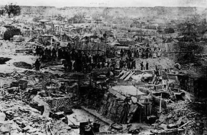
Image 2. Shows victims of the earthquake searching the ruins of their homes for anything of                                                                            value


Image 3. Shows victims looking at the ruins of their small community after a landslide                                                                  following the earthquake

Video:

https://youtu.be/uhJe8uqW1Rk

Citations: 

Fuller, Pierre. “Contents.” Disaster History, https://disasterhistory.org/gansu-earthquake-1920.

“This Day in History: Massive Haiyuan Earthquake Devastates Gansu.” Refer China, 16 Dec. 2020, https://www.referchina.com/2020/12/This_Day_in_History__Massive_Haiyuan_Earthquake_Devastates_Gansu_27789.html.

Suddath, Claire. “Top 10 Deadliest Earthquakes.” Time, Time Inc., 13 Jan. 2010, http://content.time.com/time/specials/packages/article/0,28804,1953425_1953424_1953443,00.html.

“The Deadliest Earthquakes to Rock the World.” New York Daily News, New York Daily News, https://www.nydailynews.com/news/deadliest-earthquakes-rock-world-gallery-1.2764182?pmSlide=1.2764173.

“The 1920 Haiyuan Earthquake: One of the 20th Century's Deadliest.” AIRWorldwide, https://www.air-worldwide.com/blog/posts/2020/12/the-1920-haiyuan-earthquake-one-of-the-20th-centurys-deadliest/.


Sunday, September 11, 2022

Mexico City, Mexico- Earthquake of 1985

    On September 19, 1985 at 7:18 Mexico was hit with a large earthquake of a magnitude-8.0. The earthquake's epicenter occurred in the state of Michoacán, Mexico and was 200 miles from Mexico City. (Britannica 2022) It was estimated to have lasted 3-4 minutes long. 

    The earthquake was one that was devastating to the country due to the fact that they were not prepared for it. The quake killed more than, "10,000 and left another 30,000 others injured and as many as a quarter of a million people homeless." ( History 2009). The earthquake did occur some 200 miles from Mexico city but it was recorded that houses did get knocked down in the areas closer to the epicenter the majority of the damage was seen in Mexico city. The reason that Mexico city was hurt some much in the earthquake was because of the ground that it sits on. Mexico city is surrounded by volcanoes and mountains and long ago the city was "...covered by lakes in ancient times. As the aquifer under the city has slowly drained, it has been discovered that the city sits atop a combination of dirt and sand that is much less stable than bedrock and can be quite volatile during an earthquake." (NIST 2017) The ground type under the city amplified the quakes that had come from the main epicenter causing the continued shaking that devastated the city. The amount of buildings that were damaged in the quake turned out to be "...3,000 buildings in Mexico City were demolished and another 100,000 suffered serious damage"(NIST 2017). 

    The lesson of the the 1985 Mexico earthquake was how little prepared the city was for something like that. They had no early warning systems in place back then an had no idea about the type of ground they were living on. The city also learned about how little they had up to code with building regulations in the city because of how much it was growing back then, and because of this after the earthquake, "Public transportation halted, water pipes burst and public health facilities – few of which were built to code – crumbled" ( Guardian 2015).  After this fact
the people that were living in the area that had little to no help after the earthquake wanted change in the government because of what they were doing and not helping the working class people who had lost there homes. People became mad and was "...criticizing the government's decision to spend international aid on the reconstruction of schools and hospitals instead of housing" (Orme 1986). The main culprit of the main damage that was recorded in the earthquake was due to the ground that the city was built on and how it acted in the quake. The government learned after the quake that they did not truly understand the ground they were built on and had learned that they need to go deeper with future builds and reach the bed rock to build on.


https://www.britannica.com/video/179495/more-office-building-earthquake-Mexico-City-Torre-2009

This video talks about the earth quake and shows footage of how the ground would have acted under the city. The video shows the design of a new build that incorporated shock absorbing technology to mitigate the tall building form collapsing in future earthquakes. 

Works cited

Britannica, The Editors of Encyclopedia. "Mexico City earthquake of 1985". Encyclopedia Britannica,             12 Sep. 2022, https://www.britannica.com/event/Mexico-City-earthquake-of-1985. Accessed 12             September 2022.

“Earthquake Mexico 1985.” NIST, 6 Jan. 2017, https://www.nist.gov/el/earthquake-mexico-1985.

History.com Editors. “1985 Mexico City Earthquake.” History.com, A&E Television Networks, 9 Nov. 2009, https://www.history.com/topics/natural-disasters-and-environment/1985-mexico-city-earthquake.

“The Mexico City Earthquake, 30 Years on: Have Its Lessons Been Forgotten?” The Guardian, Guardian News and Media, 18 Sept. 2015, https://www.theguardian.com/cities/2015/sep/18/mexico-city-earthquake-30-years-lessons.

Orme, William A. “Thousands Still Homeless 1 Year After Mexico Quake.” The Washington Post, WP Company, 20 Sept. 1986, https://www.washingtonpost.com/wp-srv/inatl/longterm/mexico/stories/860920.htm.

2001 Southern Peru Earthquake


On June 25, 2001, at approximately 3:33 pm local time, a massive earthquake measuring 8.4 on the Richter Scale struck off the coast of Southern Peru (Keefer and Mosely, 2004). This earthquake subsequently created a tsunami that would wash up to half a mile inland along the coastal department of Arequipa (ReliefWeb, 2001). This earthquake and tsunami lead to 81 deaths and 64 missing while also causing an estimated $200.7 million dollars of damage (ReliefWeb, 2001). This earthquake would also cause almost 25 thousand homes to be destroyed and 36.7 thousand homes to be damaged (ReliefWeb, 2001). 


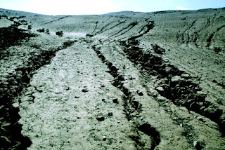
Rills widened by the earthquake.
(Keefer and Mosely, 2004)
  
This powerful earthquake would cause widespread ground failure across the country including landslides, ground cracking, micro fracturing of hillslopes, and collapses of drainage banks (Keefer and Mosely, 2004). These occurrences not only had effects on the environment but human structures and infrastructure as well. Large landslides occurred along a 20km stretch of the Pan American Highway and while the road was cleared off quickly, other more remote parts of the country would remain harder to get to (Dengler, 2001; ReliefWeb, 2001). The earthquake and tsunami would cause great damage to the farmland of the country damaging almost 41 thousand hectares of cultivation and covering 2,000 hectares of farmland in sand (Dengler, 2001; ReliefWeb, 2001).


This is a view of the tsunami damage from the highway to Camaná.
(USGS, 2001)


While the earthquake and resulting tsunami did massive economic damage the death total was relatively low which is mostly due in part by the timing of the earthquake and the preparedness of the people who live there. Most of the people were aware of tsunamis and knew that dropping water was a sign of one approaching which was easy to see as the earthquake struck during the afternoon (Dengler, 2001). This earthquake also occurred during the Peruvian winter meaning that the towns were not filled with tourists leading to the death total being much lower (Dengler, 2001). All this being said, the area still suffered great economic losses due to how most of the houses in the area were made from adobe which did not hold up well during the shaking and tsunami (ReliefWeb, 2001; Dengler, 2001). 


 Magnitudes experienced by the region from large earthquakes since 1604.
Star represents 2001 Earthquake.
(Giovanni, Beck, and Wagner, 2002) 


Major earthquakes have occurred along the fault in 1604, 1784, and 1868 all measuring 8+ intensities with the 1868 earthquake clocking in at an 8.8-9.0 magnitude (Giovanni, Beck, and Wagner, 2002; Hayes, Myers et al., 2004) In addition, large earthquakes have occurred along the Peru-Chelian trench in 1942, 1974, and 1996 all being 7.5+ magnitude. The fact that large earthquakes are a semi-normal occurrence in the area helps to prepare the citizens and give them experience to be able to deal with future earthquakes, but their buildings and infrastructure were not prepared for this event. For future earthquakes and tsunamis, reinforced infrastructure is necessary to avoid more economic and human losses in the future. In addition, alarms and warning systems should be put in place to help warn people if one were to occur at night or during tourist seasons when a large portion of the population could be inexperienced. 


This is a preliminary animation of the 2001 Peru tsunami.
YouTube. (2010). Preliminary Animation of the 23 June 2001 Peru Tsunami. YouTube. Retrieved September 14, 2022, from https://www.youtube.com/watch?v=xLNBJIp2sMU. 


Citations

Giovanni, M. K., Beck, S. L., & Wagner, L. (2002, November 6). The June 23, 2001 Peru earthquake and the southern Peru subduction zone Retrieved September 12, 2022, from https://agupubs.onlinelibrary.wiley.com/doi/full/10.1029/2002GL015774


Hayes, G.P., Myers, E.K., Dewey, J.W., Briggs, R.W., Earle, P.S., Benz, H.M., Smoczyk, G.M., Flamme, H.E., Barnhart, W.D., Gold, R.D., and Furlong, K.P., (2017), M 8.4 - 6 km SSW of Atico, Peru https://earthquake.usgs.gov/earthquakes/eventpage/official20010623203314130_33/executive


Keefer, D. K., & Moseley, M. E. (2004, July 19). Southern Peru desert shattered by the great 2001earthquake: Implications for paleoseismic and paleo-El Niño–Southern Oscillation records. Retrieved September 12, 2022, from https://www.pnas.org/doi/full/10.1073/pnas.0404320101


Dengler, L. (2001, December). Impacts of the June 23, 2001 Peru tsunami. NASA/ADS. Retrieved September 12, 2022, from https://ui.adsabs.harvard.edu/abs/2001AGUFM.S52A0617D/abstract


ReliefWeb. (2001, August 9). Peru - Earthquake Fact Sheet #6, Fiscal Year (FY) 2001 RetrievedSeptember 12, 2022, from https://reliefweb.int/report/peru/peru-earthquake-fact-sheet-6-fiscal-year-fy-2001

Pictures

USGS (2001), Damage to structures following the 2001 Peru tsunami. U.S. Geological Survey. (n.d.). Retrieved September 12, 2022, from https://www.usgs.gov/media/images/damage-structures-following-2001-peru-tsunami