On June 25, 2001, at approximately 3:33 pm local time, a massive earthquake measuring 8.4 on the Richter Scale struck off the coast of Southern Peru (Keefer and Mosely, 2004). This earthquake subsequently created a tsunami that would wash up to half a mile inland along the coastal department of Arequipa (ReliefWeb, 2001). This earthquake and tsunami lead to 81 deaths and 64 missing while also causing an estimated $200.7 million dollars of damage (ReliefWeb, 2001). This earthquake would also cause almost 25 thousand homes to be destroyed and 36.7 thousand homes to be damaged (ReliefWeb, 2001).
 |
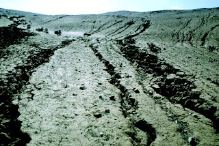
Rills widened by the earthquake. (Keefer and Mosely, 2004) |
 |
This is a view of the tsunami damage from the highway to Camaná. (USGS, 2001) |
While the earthquake and resulting tsunami did massive economic damage the death total was relatively low which is mostly due in part by the timing of the earthquake and the preparedness of the people who live there. Most of the people were aware of tsunamis and knew that dropping water was a sign of one approaching which was easy to see as the earthquake struck during the afternoon (Dengler, 2001). This earthquake also occurred during the Peruvian winter meaning that the towns were not filled with tourists leading to the death total being much lower (Dengler, 2001). All this being said, the area still suffered great economic losses due to how most of the houses in the area were made from adobe which did not hold up well during the shaking and tsunami (ReliefWeb, 2001; Dengler, 2001).
 |
| Magnitudes experienced by the region from large earthquakes since 1604. Star represents 2001 Earthquake. (Giovanni, Beck, and Wagner, 2002) |
Major earthquakes have occurred along the fault in 1604, 1784, and 1868 all measuring 8+ intensities with the 1868 earthquake clocking in at an 8.8-9.0 magnitude (Giovanni, Beck, and Wagner, 2002; Hayes, Myers et al., 2004) In addition, large earthquakes have occurred along the Peru-Chelian trench in 1942, 1974, and 1996 all being 7.5+ magnitude. The fact that large earthquakes are a semi-normal occurrence in the area helps to prepare the citizens and give them experience to be able to deal with future earthquakes, but their buildings and infrastructure were not prepared for this event. For future earthquakes and tsunamis, reinforced infrastructure is necessary to avoid more economic and human losses in the future. In addition, alarms and warning systems should be put in place to help warn people if one were to occur at night or during tourist seasons when a large portion of the population could be inexperienced.
This is a preliminary animation of the 2001 Peru tsunami.
YouTube. (2010). Preliminary Animation of the 23 June 2001 Peru Tsunami. YouTube. Retrieved September 14, 2022, from https://www.youtube.com/watch?v=xLNBJIp2sMU.
Citations
Hayes, G.P., Myers, E.K., Dewey, J.W., Briggs, R.W., Earle, P.S., Benz, H.M., Smoczyk, G.M., Flamme, H.E., Barnhart, W.D., Gold, R.D., and Furlong, K.P., (2017), M 8.4 - 6 km SSW of Atico, Peru https://earthquake.usgs.gov/earthquakes/eventpage/official20010623203314130_33/executive
Keefer, D. K., & Moseley, M. E. (2004, July 19). Southern Peru desert shattered by the great 2001earthquake: Implications for paleoseismic and paleo-El Niño–Southern Oscillation records. Retrieved September 12, 2022, from https://www.pnas.org/doi/full/10.1073/pnas.0404320101
Dengler, L. (2001, December). Impacts of the June 23, 2001 Peru tsunami. NASA/ADS. Retrieved September 12, 2022, from https://ui.adsabs.harvard.edu/abs/2001AGUFM.S52A0617D/abstract
ReliefWeb. (2001, August 9). Peru - Earthquake Fact Sheet #6, Fiscal Year (FY) 2001 RetrievedSeptember 12, 2022, from https://reliefweb.int/report/peru/peru-earthquake-fact-sheet-6-fiscal-year-fy-2001
No comments:
Post a Comment
Note: Only a member of this blog may post a comment.