Description
On April 1, 1946, an 8.6M earthquake hit Unimak Island of the Aleutian Islands in Alaska (53.492°N 162.832°W). The event spawned a tsunami that traveled as far south as Antarctica, greatly impacting the islands of Hawaii. (López and Okal). The end date of the disaster is not known, though it is likely that recovery efforts extended to months or years after the fact, as substantial damage to infrastructure occurred in Hawaii.
Event Summary
At 3:28am AST, an earthquake occurred along the Alaska-Aleutian trench, nearly 85 miles south of Unimak Island (Dengler 2018). The earthquake registered an 8.6 magnitude and was characterized by a slow rupture, which has made it difficult to discern the exact depth of the focus; seismologists speculate it may have been an interplate thrust event, however. Severe local damage did not occur from shaking, but rather from tsunami waves that the earthquake produced (López and Okal 2006). A study of aftershocks in the Aleutian-Alaska region notes that the aftershock area of the quake was remarkably close to the ocean trench, suggesting that the tsunami waves were caused by aftershocks rather than the initial quake itself (Tape and Lomax, 2022). The only major damage that occurred in Alaska was the destruction of the Scotch Cap Lighthouse, a Coast Guard station on the island of Unimak. All five Coast Guardsmen who were on duty the morning of April 1 lost their lives (Dengler 2018). Little else is known about the other instances of damage to the human environment in Alaska, nor the tsunami's effects on the physical environment. The next known area to be affected by the tsunami was Hawaii, where the town of Hilo on the Big Island was hit the hardest. As the tsunami approached, the recession of the tide and subsequent exposure of the sea floor attracted both children and adults to watch the spectacle; they were the first to experience the wave, some getting drawn out to sea (Dengler 2018). Later, witnesses recall seeing a huge wave roll into the center of Hilo, one survivor describing it as a "great, big black wall." After the waves returned to normal, 159 people had died and homes and other infrastructure were destroyed (Vorsino 2016).
Discussion
The April Fool's tsunami has had major implications for the people of Hawaii, namely awareness of the destructive capabilities of tsunamis as well as their warning signs. The loss of human life took a heavy toll on the people who witnessed the disaster, and has lived on in their memory ever since. It is probable that the memory of the event has moved past the individual setting and lives in the history of the Hilo community. Rather than investigating waves that have rapidly receded, Hawaii residents now know "to run from the ocean" (Vorsino 2016). Perhaps if Hawaiians had that awareness prior to April 1, 1946, the human loss would not have been so severe. Another major impact of the tsunami was how it affected seismological measurement and disaster warning systems; only three years after the disaster, the first tsunami warning system became operational at Pearl Harbor and began paving the way for the developments in tsunami warning technology ever since (Dengler 2018). The emergency response to the disaster was limited not only in timeliness but also in manpower and "rescue infrastructure," or the amount of air- and watercraft available to aid search and rescue missions. For example, when Herbert Nishimoto was swept out to sea in the wake of the tsunami, a plane that spotted him floating in the sea dropped down an inflatable raft, but was unable to assist any further (Tucker, 2014). If a similar disaster happened today, there would likely be a rescue helicopter sweeping the area and dropping down to lift people up -- a much more effective aid. Improvements in warning technology and rescue personnel, as well as a more educated population, makes Hawaii better prepared should a similar disaster strike its shores again.
Photos
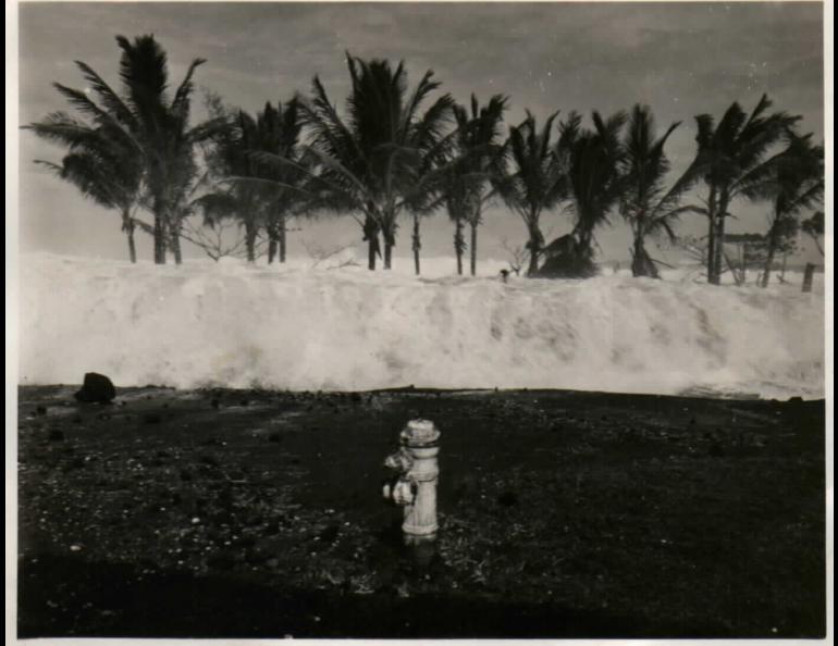
One of many tsunami waves hit the beach of Hilo.
Rather ironically, this one heads toward a fire hydrant.
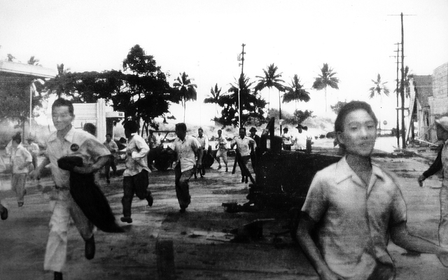
People of Hilo flee from an incoming wave.
Picture of the life raft dropped to 16-year old Nishimoto
and two other boys. The group had to fend off sharks the
previous evening.
Video
Old-style newsreel depicting the disaster
Sources
Dengler, Lori. “Not My Fault: The Tsunami of April 1, 1946 Was No April Fools Joke,” n.d., The Times Standard. Accessed October 31, 2022.
López, A. M. and E. A. Okal. “M 8.6 - 1946 Aleutian Islands (Unimak Island) Earthquake, Alaska.” Accessed October 31, 2022.
https://earthquake.usgs.gov/earthquakes/eventpage/official19460401122901_30/region-info.
Tape, Carl, and Anthony Lomax. “Aftershock Regions of Aleutian-Alaska Megathrust Earthquakes, 1938–2021.”
Journal of Geophysical Research: Solid Earth 127, no. 7 (2022): e2022JB024336.
https://doi.org/10.1029/2022JB024336.
Tucker, Keahi. “27 Hours Adrift: Surviving the 1946 April Fool’s Day Tsunami.”
Hawaii News Now. Accessed October 31, 2022.
https://www.hawaiinewsnow.com/story/27350169/exclusive-27-hours-adrift.
Vorsino, Mary. “70 Years on, April Fools’ Day Tsunami Painful Reminder of Ocean’s Destructive Force.”
Hawaii News Now. Accessed October 31, 2022.
https://www.hawaiinewsnow.com/story/31624669/70-years-on-april-fools-day-tsunami-painful-reminder-of-oceans-destructive-force.


No comments:
Post a Comment
Note: Only a member of this blog may post a comment.