Featured Post

Welcome to the Blog

Welcome to our Natural Disasters Blog!  Below you will post your disaster summaries as you complete them. Remember to initiate a post with t...

Tuesday, September 17, 2024

1935 Quetta Earthquake


Figure 1: Map of earthquakes in the Quetta region of Pakistan.

  On May 31, 1935, at 3:03 A.M., a 7.6 magnitude earthquake razed the streets of Quetta. Quetta was a mid-sized city in the arid badlands of the province of Balochistan, British India (modern day Pakistan) (Skrine 1936). The city held a strong military presence which was in place to protect the border of British India, which had caused the population to ascend rapidly. The families of the soldiers often immigrated along with the soldiers, as well as merchants and government officials to provide services and city planning. The quick rise in population, as well as the caste system that was prevalent in British India, led to distinct districts that were segregated based upon race and occupation (Global Shelter Cluster 2019). These districts varied in building quality, location, and population density. The poorest district was made of tall, mud and brick buildings and were placed in close proximity to each other. A district was devoted to government officials, and the buildings there were well built. The military districts were the best suited for an earthquake, as they were not on alluvial soil and had many open areas and smaller buildings (Global Shelter Cluster 2019). The earthquake in Quetta was caused by a surface-rupturing left-lateral strike-slip even along the Chaman Fault and the shaking could be felt for up to 100 miles. This region has significant amounts of tectonic activity, as it is in between the Indian, Eurasian, and the Himalayan plates (Reynolds et al. 2019). When the earthquake struck, the poorest districts and the district for government officials was where the shaking was strongest. These districts were built upon alluvial soil, which holds moisture and causes liquefaction to the soil during an earthquake. Since the poorest district had poorly constructed buildings and a high population density, this intense shaking almost completely decimated this district (Global Shelter Cluster 2019). As most people were sleeping when the shaking first occurred, these poorly constructed buildings fell apart on them in their sleep. Those who were awake could often not escape their buildings, as there was a lack of exterior exits (Skrine 1936). The district which hosted the government officials also experienced extensive damage, but the casualties were lessened due to the buildings being more spread apart, which allowed more people to escape their buildings. The military districts survived without much damage, due to the well constructed buildings and due to the soil being drier than the alluvial soil of the poorer districts (Global Shelter Cluster 2019). In the aftermath of this terrible earthquake, 60,000 citizens of Quetta were killed and there was approximately $25 million of damage, adjusted to USD in 2001 (NCEI 2024). 


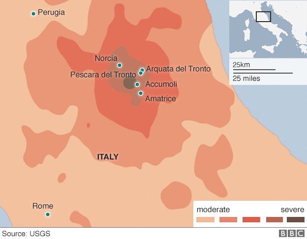
Figure 2: Diagram of the tectonic activity around Quetta.


There were significant problems in the aftermath of the earthquake, as would be the case in any earthquake with this level of loss of human life and property damage. Immediately, the military declared martial law, set up a hospital, dug up survivors, and opened camps for survivors. The military then cut off the city as a safety measure, to keep people away from disease caused by rotting bodies (Global Shelter Cluster 2019). The military had to ward off looters, who had traveled from the frontier to loot what they could (The Associated Press 1935). Tents and camps were erected, but these tents were not properly prepared for the weather, nor was there anywhere near enough of them. Thousands of people were evacuated by train, though there was significant racial bias during the evacuation, as British citizens were prioritized. A Relief Fund was also established, in which $7.1 million, adjusted to USD in 2018, was raised worldwide to help with reconstruction efforts. Much of this aid also was troubled by racial bias, with British citizens gaining much of the aid. There were significant strides to improve the infrastructure, but during winter, no progress could be made due to improper equipment (Global Shelter Cluster 2019). When reconstruction could resume, the city planners implemented a strict city code to prevent another disastrous event, despite local uproar over the high costs of these improvements. Wider streets, improved sewage systems, exterior exits on buildings, steel-reinforced concrete, one story buildings, and square shaped buildings were all implemented across the city. Squared shaped buildings were found to have collapsed less during the earthquake than rectangular buildings, due to less stress up the corners, explaining the code (Global Shelter Cluster 2019). During an earthquake in 1955, many of these new structures performed admirably and there was significant reduction in deaths and damage (Reynolds et al. 2019).


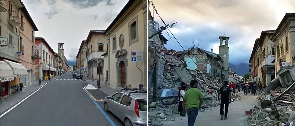
Figure 3: The destruction caused by the earthquake in Quetta.


        Overall, the response and recovery to this tragedy was admirable in many ways, yet could have improved. The improvements made to the city after the event could have been made prior, if as much care was taken to other citizens as much as British citizens and the military. However, despite the problems caused by racial bias, the military’s response was quick and effective given the scale of the task laid before them. The cutting off of the area prevented the catastrophe from spreading while the military could rescue civilians and establish hospitals and camps. The evacuation could have been more effective, as British citizens were given preferential treatment. The population continued to grow as labor came in to rebuild as well. One of the major problems was the lack of shelter, as well as the available shelter being ineffective in the climate (Global Shelter Cluster 2019). This is an area in which the government was woefully unprepared, and should be improved upon. However, despite the many issues plaguing this disaster, they performed well in the aftermath.

https://www.youtube.com/watch?v=ZY0sabJFsAA

Video: The video briefly shows the destroyed city and the reconstruction of the city. It also shows the living conditions of those displaced by the event, as well as the builders implementing steel reinforced concrete to their buildings to prevent another disaster of this magnitude.

Works Cited

Global Shelter Cluster. (2019, May). Shelter Projects 2017-2018. The Shelter Project. http://shelterprojects.org/shelterprojects2017-2018/ShelterProjects_2017-2018_lowres_web.pdf 

Reynolds, K., Copley, A., & Hussain, E. (2015). Evolution and dynamics of a fold-thrust belt: the Sulaiman Range of Pakistan. Geophysical Journal International, 201(2), 683–710.

Significant Earthquake Information. NCEI Global Historical Hazard Database. (n.d.). https://www.ngdc.noaa.gov/hazel/view/hazards/earthquake/event-more-info/3550

Skrine, C. P. (1936). The Quetta earthquake. The Geographical Journal, 88(5), 414. https://doi.org/10.2307/1785962

The Associated Press. (1935, June 1). 20,000 killed by india quake; city shattered. Chicago Daily Tribune, pp. 1–1.

The 2023 Turkey-Syria Earthquake

On February 6, 2023, a 7.8 magnitude earthquake struck near the border of Turkey and Syria (United Nations 2023). The first earthquake was centered in the Pazarcik district of Kahramanmaras province on the East Anatolian fault and was followed by over 100 aftershocks including a 7.6 magnitude earthquake (Al Jazeera 2023 and USGS 2023). It was a strike-slip earthquake like the ones found along the San Andreas fault in California (Hernandez & Brumfiel 2023). Believed to be the largest earthquake in this region in eighty years, the event killed over 41,000 people in Turkey and approximately 4,800 people in Syria (Al Jazeera 2023 and Hernandez & Brumfiel 2023). Thousands of buildings collapsed leaving 210 million tons of ruble (United Nations 2023). About 1.5 million people were left homeless after the quakes (United Nations 2023).

This map shows the tectonic plates in the region and their direction. Along the East Anatolian Fault, one can see the transform fault where the earthquake occurred. The two stars mark the location of the two biggest quakes (USGS 2023). 

This map shows the below average temper-
atures in the region. From this it is apparent
that the weather put intense pressure on the
the displaced people as well as well as on the
rescue teams who were slowed by the weather
(Al Jazeera).
Many people whose homes were not destroyed during the earthquake initially refused to live in them out of fear of another earthquake and more buildings collapsing (McCarthy et al. 2023). This became a major issue as people living in tents and vehicles were exposed to freezing temperatures (McCarthy et al. 2023). Winter storms also delayed rescue and aid operations (Al Jazeera 2023). Providing aid in Syria was complicated by the ongoing civil war as parts of the rebel held northwestern portion of the country were heavily affected (McCarthy et al. 2023). This issue was resolved by the United Nations which took responsibility over transporting aid from the government controlled to the rebel controlled regions (McCarthy et al. 2023). 

Discussions and Consequences

There are multiple factors that contributed to the severity of the earthquake. After the disaster, the Turkish government arrested thirty-one contractors who oversaw the construction of a large portion of the collapsed buildings (McCarthy et al. 2023). This act implies that the contractors disregarded earthquake-related building codes while constructing the buildings which put them, at least partially, at fault for the deaths.

This image shows a man looking for survivors among the rubble. It 
shows the extent of the damage among the buildings in Turkey 
where building codes were in place to prevent such disasters
(Hernandez & Brumfiel 2023). 

The political situation in Syria slowed the process of bringing foreign aid into the country. An alliance with Russia, slowed the process of opening the country’s border with Turkey with two border crossings for aid being approved nearly an entire week after the initial earthquake (McCarthy et al. 2023). The civil war in Syria also slowed the distribution of aid in the country (McCarthy et al. 2023). A conclusion to be drawn from this situation is that, in order for aid to be distributed effectively, countries and political sects must agree upon mutually benefitting treaties for these types of situations before the disasters occur. The United Nations could be an adequate agent to carry this task out.

Finally, controlling human response, specifically fear, was a major issue in the aftermath of this earthquake. People were being exposed to freezing temperatures because they were afraid to live in safe buildings due to witnessing the failures of unsafe buildings (McCarthy et al. 2023). To mitigate this problem, Turkey could have educated residents in how to determine which buildings were still safe. This might have enabled a few to overcome their fear. Having temporary structures stored in earthquake prone areas could be another way to help provide housing to people who either lost their homes or refuse to live in their old homes out of fear. This solution though would require a large amount of resources which might make it impractical to utilize.

Below is a link to a video from Sky News on the 2023 earthquake. It includes footage of buildings collapsing and of rescue efforts.


References

Al Jazeera. (2023). Turkey, Syria earthquake current death toll: Live Tracker. https://www.aljazeera.com/news/2023/2/6/turkey-syria-earthquake-death-toll-and-devastation-live-tracker. Last Accessed 17 September 2024

Hernandez & Brumfiel (2023). Here’s what we know about what caused the Turkey earthquake. NPR. https://www.npr.org/2023/02/07/1154913148/turkey-earthquake-fault-lines-syria. Last Accessed 17 September 2024

McCarthy, Guy, Chowdhury, & Hammond. (2023). February 13, 2023 over 36,000 dead from quake in Turkey and Syria. CNN. https://www.cnn.com/middleeast/live-news/turkey-syria-earthquake-updates-2-13-23-intl/index.html. Last Accessed 17 September 2024

Sky News. (2023). Turkey-Syria earthquake: Buildings crumble as deadly earthquakes hit. YouTube. https://www.youtube.com/watch?v=0jZE4p1SOvg. Last Accessed 17 September 2024

United Nations. (2023). Türkiye-Syria earthquake response. United Nations. https://www.un.org/en/turkiye-syria-earthquake-response. Last Accessed 17 September 2024

USGS. United States Geological Survey (2023). New interactive geonarrative explains the 2023 Turkey, earthquake sequence: U.S. Geological Survey. New Interactive Geonarrative Explains the 2023 Turkey, Earthquake Sequence | U.S. Geological Survey. https://www.usgs.gov/programs/earthquake-hazards/news/new-interactive-geonarrative-explains-2023-turkey-earthquake. Last Accessed 17 September 2024

2011 Tohoku Earthquake

    On March 11, 2011, a catastrophic magnitude 9.0 earthquake struck off the eastern coast of Tohoku, Japan, causing widespread devastation. This powerful earthquake was the strongest ever recorded in Japan and triggered a massive tsunami, generating waves that reached staggering heights of up to 40 meters. The earthquake caused significant physical impacts, including the shifting of the Earth’s axis, land subsidence, and extensive damage to infrastructure. Coastal areas experienced overwhelming flooding, leading to substantial erosion and the displacement of sediment (NCEI Global Historical Hazard Database, n.d.).
    The human toll of this disaster was staggering. The combined effects of the earthquake and tsunami resulted in the tragic loss of approximately 16,000 lives, with thousands more individuals sustaining injuries and being displaced from their homes. Entire communities were obliterated, leaving hundreds of thousands of people homeless. The Fukushima Daiichi Nuclear Power Plant suffered severe damage, leading to core meltdowns and the release of radioactive materials. This catastrophe prompted a long-term evacuation of nearby areas and caused significant environmental contamination (Shibahara, 2011).
    The economic impact of this disaster was profound, with billions of dollars in damages and long-term recovery costs. This catastrophic event underscored the vulnerability of densely populated coastal regions to natural hazards and has contributed to global conversations about disaster preparedness and nuclear safety (Shibahara, 2011).

    The Tohoku earthquake and tsunami presented numerous opportunities for mitigating its impacts. Although Japan had advanced warning systems in place, the integration of real-time data and prompt dissemination of warnings could have enhanced their effectiveness. Stricter building codes and retrofitting practices could have minimized physical damage. Even though Japan has stringent earthquake-resistant construction standards, the magnitude of the quake exceeded the designs for many structures (Abe & Imamura, 2013). The Fukushima nuclear disaster emphasized the necessity of rigorous safety protocols in nuclear facilities. A more robust design, including elevated structures and improved backup power systems, could have mitigated the risk of a catastrophic failure (Japan After 3/11, n.d.).

    The aftermath of the Tohoku earthquake underscored the importance of community resilience and preparedness. It highlighted the need for community-based disaster planning and education and training programs to empower communities to respond more effectively. The disaster also led to a reevaluation of global nuclear energy policies, emphasizing the need for sustainable and safe energy alternatives. Japan's decision to phase out certain nuclear power operations and invest more in renewable energy reflects a significant shift in energy policy driven by the disaster's lessons (Goto et al., 2021).

    In conclusion, the Tohoku earthquake was a pivotal event that delineated the profound impacts natural disasters can have on both the physical and human environment. It revealed critical areas for improvement in disaster preparedness, infrastructure resilience, and nuclear safety, which are essential for better equipping societies to handle future disasters and enhancing overall resilience.


Damages caused by Tohoku tsunami


Image shows magnitude of earthquake


Japanese Ground Self-Defense Force in rescue from aftermath of tsunami and earthquake

This video shows the damage of the Tohoku tsunami in action. Footage shows the tsunami swamping cities and destroying buildings.


References

Abe, I., & Imamura, F. (2013). PROBLEMS AND EFFECTS OF a TSUNAMI INUNDATION FORECAST SYSTEM DURING THE 2011 TOHOKU EARTHQUAKE. Journal of JSCE, 1(1), 516–520. https://doi.org/10.2208/journalofjsce.1.1_516

Education | National Geographic Society. (n.d.). https://education.nationalgeographic.org/

Goto, K., Ishizawa, T., Ebina, Y., Imamura, F., Sato, S., & Udo, K. (2021). Ten years after the 2011 Tohoku-oki earthquake and tsunami: Geological and environmental effects and implications for disaster policy changes. Earth-Science Reviews, 212, 103417. https://doi.org/10.1016/j.earscirev.2020.103417

Japan after 3/11. (n.d.). Google Books. https://books.google.com/books?hl=en&lr=&id=n4rpDAAAQBAJ&oi=fnd&pg=PA317&dq=the+nuclear+impacts+caused+by+Tohoku+earthquake+&ots=RvWbiuCWeX&sig=T2-KwqtVq3HUSsADIKpyMQGC51s#v=onepage&q=the%20nuclear%20impacts%20caused%20by%20Tohoku%20earthquake&f=false

Koshimura, S., Hayashi, S., & Gokon, H. (2014). The impact of the 2011 Tohoku earthquake tsunami disaster and implications to the reconstruction. SOILS AND FOUNDATIONS, 54(4), 560–572. https://doi.org/10.1016/j.sandf.2014.06.002

National Geographic. (2011, June 13). Rare video: Japan Tsunami | National Geographic [Video]. YouTube. https://www.youtube.com/watch?v=oWzdgBNfhQU

NCEI Global Historical Hazard Database. (n.d.). https://www.ngdc.noaa.gov/hazel/view/hazards/earthquake/event-more-info/9799

Rafferty, J. P., & Pletcher, K. (2024, September 14). Japan earthquake and tsunami of 2011 | Facts & Death Toll. Encyclopedia Britannica. https://www.britannica.com/event/Japan-earthquake-and-tsunami-of-2011/Relief-and-rebuilding-efforts

Shibahara, S. (2011). The 2011 Tohoku earthquake and devastating tsunami. The Tohoku Journal of Experimental Medicine, 223(4), 305–307. https://doi.org/10.1620/tjem.223.305

Simons, M., Minson, S. E., Sladen, A., Ortega, F., Jiang, J., Owen, S. E., Meng, L., Ampuero, J. P., Wei, S., Chu, R., Helmberger, D. V., Kanamori, H., Hetland, E., Moore, A. W., & Webb, F. H. (2011). The 2011 Magnitude 9.0 Tohoku-Oki Earthquake: Mosaicking the Megathrust from Seconds to Centuries. Science, 332(6036), 1421–1425. https://doi.org/10.1126/science.1206731


Amatrice Italy Earthquake 2016


Italy earthquake toll rises to 297 after two die of injuries - BBC News
USGS map of Central Italy Earthquake
In the early morning hours of August 24, 2016, picturesque regions of Central Italy were jolted awake by a massive earthquake. Registering at 6.2 magnitude, the earthquake’s epicenter was near Accumoli, but its impact rippled outward, devastating the towns of Amatrice, Arquata del Tronto, and Pescara del Tronto (U.S. Geological Survey, 2016). This area is no stranger to seismic activity, as it lies near the Apennine fault system that runs through the mountains (National Institute of Geophysics and Volcanology, 2016). The earthquake struck particularly hard in rural areas, where towns famous for their medieval architecture and stone structures were unprepared for such a devastating disaster (Reuters, 2016).

Amatrice, a historical town that had recently been filled with tourists, was almost completely flattened. The quake triggered a succession of aftershocks, causing more damage and deep fear in the population (European-Mediterranean Seismological Centre, 2016). Stone buildings that had stood for centuries crumbled in seconds. These structures were not equipped to withstand seismic shaking, and landslides in the mountainous terrain further isolated the region, complicating rescue efforts as debris blocked key access routes (BBC News, 2016).

The earthquake badly damaged the centre of Amatrice, shown in these two pictures of the same street before and after the quake - 24 August 2016
Before and After Photos of Amatrice

     Nearly 300 lives were lost, and many of those who survived were left trapped beneath the rubble of collapsed buildings. The earthquake injured hundreds and displaced thousands, as entire communities were forced to abandon homes that had stood for generations (Reuters, 2016). While Italian emergency services worked to locate and rescue survivors, but the sheer magnitude of the destruction left many in shock.

The economic damage was extensive, as entire towns needed to be rebuilt, and the loss of cultural heritage was incalculable, estimated to be approximately €5 billion in damage (Di Bucci & Dolce, 2021.) Amatrice, known for its medieval architecture, had buildings that had withstood centuries of change. This left the infrastructure highly vulnerable to collapse during the earthquake. Economic reliance on agriculture and tourism intensified the disaster’s socioeconomic repercussions, as both had suffered heavily from structural damage. (Di Bucci & Dolce, 2021). The earthquake revealed the vulnerability of Italy's aging infrastructure, highlighting how devastating being unprepared for seismic activity can be (U.S. Geological Survey, 2016; BBC News, 2016). 

This earthquake really emphasizes the debate around balancing the preservation of cultural heritage with the urgent need for earthquake-proof infrastructure, especially in a country has such a deep and expansive history as Italy does. Many older buildings are cultural landmarks standing for hundreds of years, which makes them highly vulnerable to collapse when earthquakes strike. For Italy, finding the balance between preserving history and protecting lives has become a crucial issue, one that is especially relevant as the country sits on multiple fault lines.

Summary of the results of the damage and usability inspections on
public and strategic buildings and structures

Di Bucci and Dolce, when researching and preparing a case study regarding this disaster, highlighted the importance of retrofitting existing buildings to meet modern  standards, as many structures in Italy are hundreds of years old and unable to resist large earthquakes. The study conducted shows that at least 50% of public buildings-which did not include schools as that was a separate inspection that 34% were unsafe for return-were considered unsafe after inspections were carried out once the main shocks had ceased. (Di Bucci & Dolce, 2021) Improved coordination between local and national authorities in response efforts would be a benefit as well, since rescue operations were hampered by poor access and delayed communication. Thankfully, there was a total of 769 million euros invested into rehabilitating the road after the damages.(Di Bucci & Dolce, 2021) Considering the inevitable seismic activity in Italy due to the fault lines, the implementation of advanced seismic monitoring technology could give the area earlier warnings, helping to mitigate the loss of life in future events.


CBS News covering the damage


References: 

BBC News. "Comparison of Amatrice Main Street Before and After the Earthquake." BBC News, 2016, ichef.bbci.co.uk/news/976/cpsprodpb/F603/production/_90897926_comp-amatrice.jpg.webp.

 BBC News. "Italy Earthquake: Death Toll Rises as Rescue Efforts Continue." BBC News, 25 Aug. 2016, www.bbc.com/news/world-europe-37171953.

BBC News. "Map Showing Earthquake-Affected Areas in Central Italy." BBC News, 2016, news.bbcimg.co.uk/news/special/2016/newsspec_14805/img/italy_quake_26_08_16_976_v3.png

 CBS News. "Italy searches for survivors of 6.2-magnitude earthquake." YouTube, 24 Aug. 2016, www.youtube.com/watch?v=ELTaNRBMWLg.

Di Bucci, Daniel, and Mauro Dolce. Super Case Study: Central Italy Earthquake, 2016. European Commission Disaster Risk Management Knowledge Centre, 2021, https://drmkc.jrc.ec.europa.eu/portals/0/knowledge/Learning_Corner/CONRIS2021 DiBucci&Dolce_SuperCaseStudy_2021_Lesson_fin.pdf

European-Mediterranean Seismological Centre. "Mw 6.2 Central Italy Earthquake 2016." EMSC, 24 Aug. 2016, www.emsc-csem.org/Earthquake/earthquake.php?id=526829.

National Institute of Geophysics and Volcanology. "The Seismic History of Central Italy." INGV, 2016, www.ingv.it/en/.

Reuters. "Italy Earthquake: Towns Devastated as Death Toll Nears 300." Reuters, 26 Aug. 2016, www.reuters.com/article/us-italy-quake/italy-earthquake-towns-devastated-as-death-toll-nears-300-idUSKCN10Z0EN.

U.S. Geological Survey. "M 6.2 Earthquake - 2km NNW of Accumoli, Italy." USGS, 24 Aug. 2016, earthquake.usgs.gov/earthquakes/eventpage/us10006g7d/executive.