Featured Post

Welcome to the Blog

Welcome to our Natural Disasters Blog!  Below you will post your disaster summaries as you complete them. Remember to initiate a post with t...

Wednesday, September 4, 2024

All Saint's Day Earthquake of 1755

In Lisbon, Portugal, on the morning of November 1, 1755, parishioners were gathering for All Saints’ Day mass and servants across the city prepared holiday meals at home over cooking fires (Trethewey, 2020). The city was bright and alive with festivities, beautiful in its historical construction. 300 km away, however, the plates that made up the Azores-Gibraltar transform fault slipped, releasing energy of a magnitude that was equivalent to 32,000 Hiroshima bombs (Trethewey, 2020). Historical records estimate that the resulting earthquake was felt at around 9:40 a.m., at a moment magnitude of 8.5-9.0 (Barkan et al., 2009). 

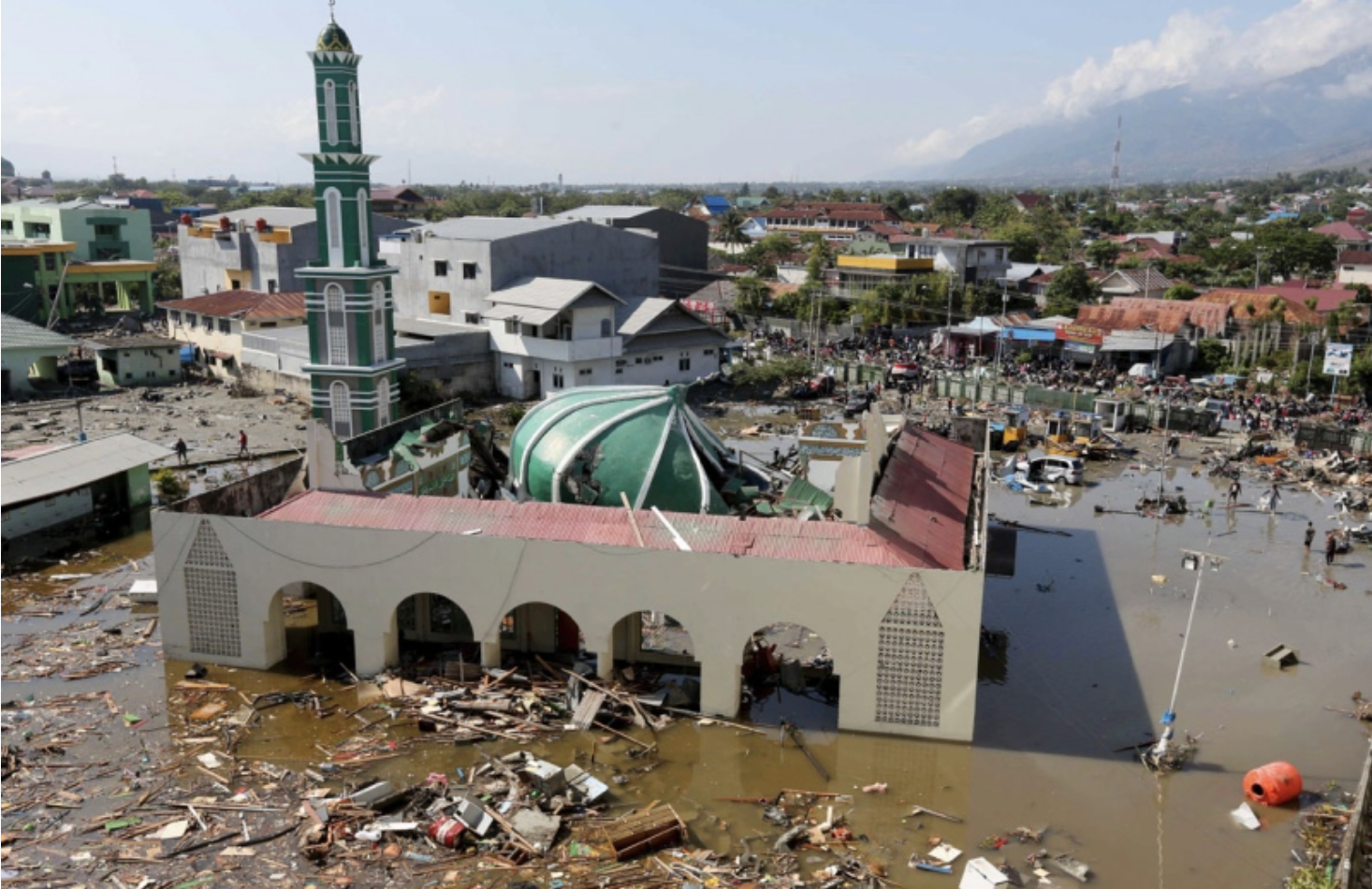
Lisbon, on the whole, was not a city prepared for an earthquake of that magnitude, or really any magnitude, for that matter (Trethewey, 2020). The three violent shocks that spanned a ten-minute period caused cathedrals to crumble and neighborhoods to be buried under their own unstable construction (Trethewey, 2020). As the winding medieval streets were buried under crumbling buildings, residents of the city fled to the only place they considered safe–the waterfront (Trethewey, 2020). What awaited them there was a tsunami 6m tall, wiping out the hundreds who had considered the waterline a safe haven from the shaking within the city (Trethewey, 2020). Where the tsunami did not reach, fire did; cooking hearths and candles that had been knocked over in the ten-minute period of three violent shakes had consolidated into greater flames and began to spread across the ruins of the city that had turned to kindling for the flames (Trethewey, 2020). The fires would burn for five straight days (cite - NISEE). 

Following the earthquake, reports of aftershocks would total 250 shocks spanning a 6 month period (Solares and Arroyo, 2004). While Lisbon arguably suffered the most during the primary event, the aftereffects of the seismic event would be felt in locations across Europe; in Spain, a survey was sent out following a decree by the King of Spain, Fernando VI of Borbon, in order to glean citizens’ perspective of the destruction (Solares and Arroyo, 2004). 


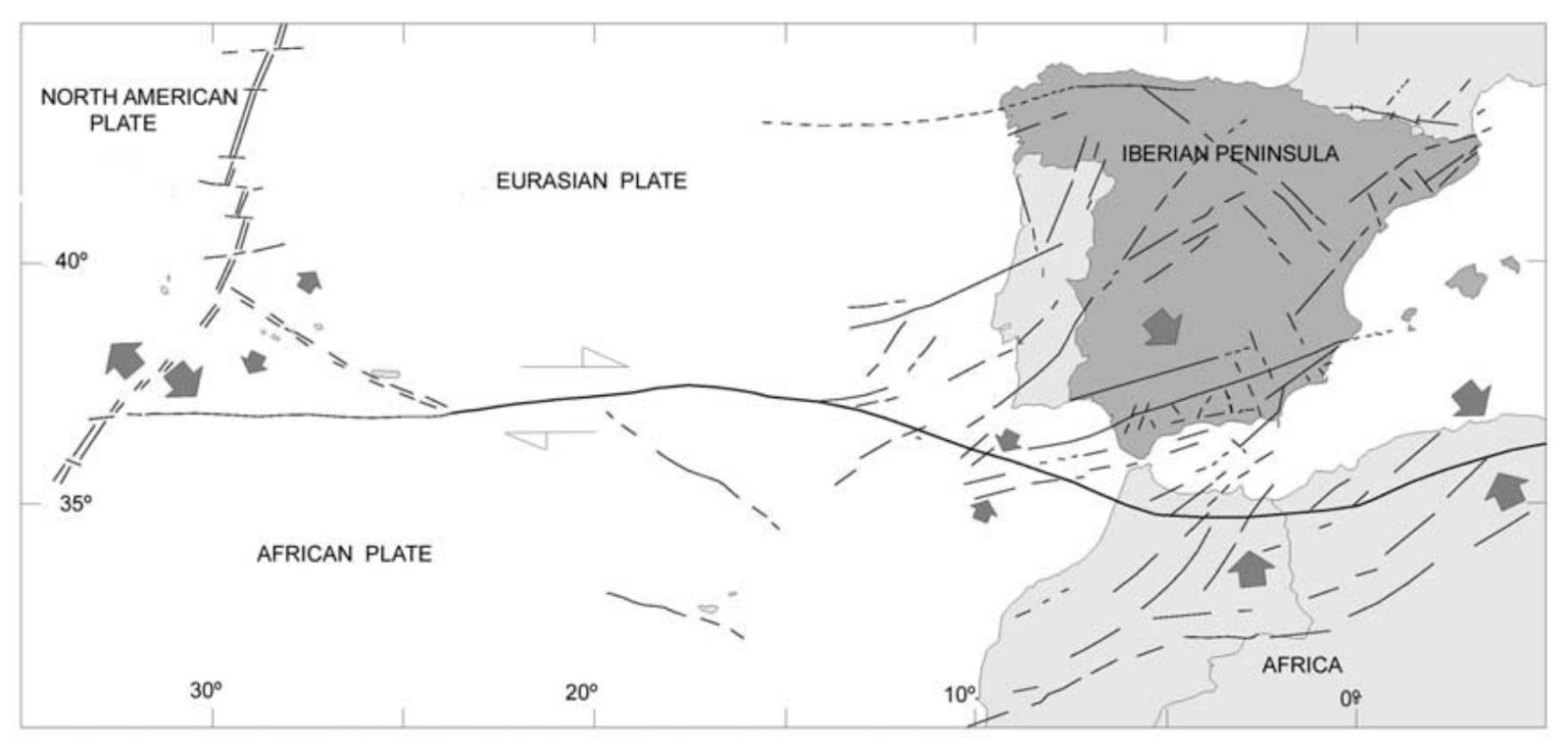
Figure 1. Map of the Azores-Gibraltar transform fault (Solares and Arroyo, 2004).


The majority of the destruction in Lisbon could be attributed to the ill-preparedness of the city for an event of such a magnitude. Following the event, however, the reign of Marquis de Pombal brought about modern thinking that would revamp the city and cultivate safer construction strategies and codes (Trethewey, 2020). Pombal’s design included building codes that required firewalls and wooden frames–Pombalina cages–that would sway with seismic forces and be able to withstand small to medium earthquakes (Trethewey, 2020). His modern designs, which took into account scientific understanding of seismology, architecture, and disaster planning, also included a grid system to expedite evacuation in future emergencies and improve overall transportation, garbage collection, and sewage (Trethewey, 2020). Drains were implemented under city streets to counteract flooding, and timber pilings were installed into the city’s sandy soil to secure building foundations (Trethewey, 2020). 

Estimates of the losses in Lisbon span various magnitudes, as discrepancies between historical records make determining deaths difficult. One estimate was a death toll of 60,000 in Lisbon alone (cite - britannica), whereas another tallied only 10,000 (Solares and Arroyo, 2004). Estimates of deaths due to the resulting tsunami tend to sit around 2,000 (Solares and Arroyo, 2004). Nevertheless, the numbers still demonstrated a sizeable percentage of the city’s overall population in 1755, 275,000 (cite - NISEE). Economic losses were also hard to pinpoint, but one destroyed warehouse was estimated to contain 1.5% of Portugal’s GDP in Brazilian diamonds (Trethewey, 2020). 


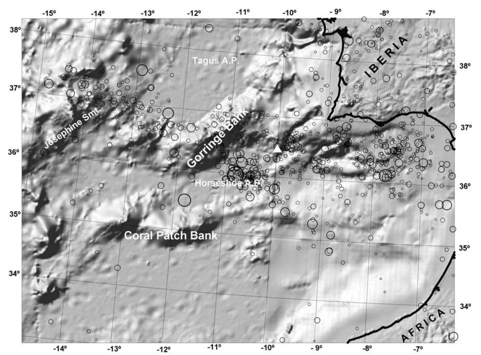
Figure 2. Seismicity map and shade relief of the Azores-Gibraltar transform fault. The represented time period spans 1915 to 2000. The white triangle is located at the location of the 1755 All Saints’ Day earthquake (Solares and Arroyo, 2004). 


Estimates of the affected area also vary, as the epicenter of the event was located in the Atlantic Ocean, in the Horseshoe Abyssal Plain (Solares and Arroyo, 2004). The estimated total area affected has been determined to be between 10-15 million km2, with Lisbon being the most affected by the quake (Solares and Arroyo, 2004).


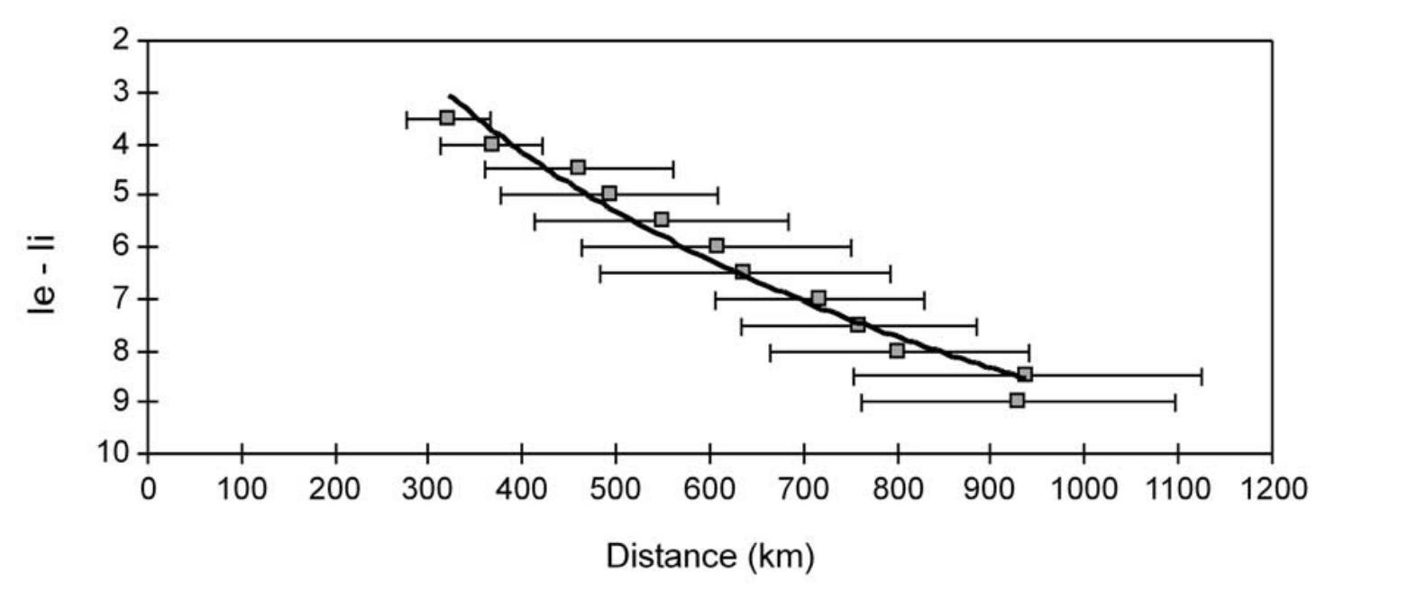
Figure 3. Intensity of earthquake (le - li) with increasing distance (km) from the epicenter (Solares and Arroyo, 2004). 


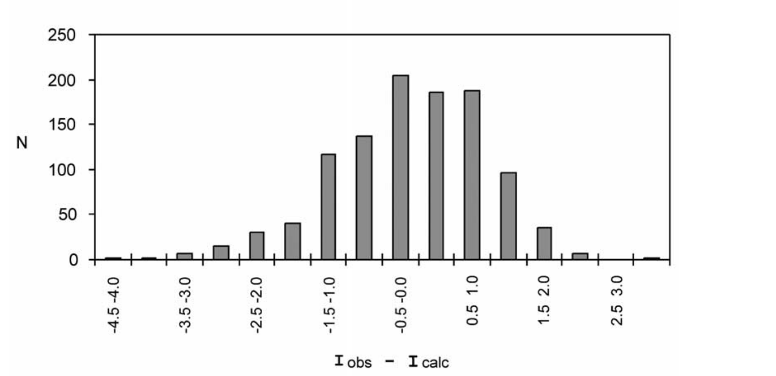
Figure 4. Differences between observed and calculated intensities of the All Saints’ Day earthquake of 1755. 


Had construction of the city been more prepared for such a natural disaster, the losses sustained might not have been so detrimental. The recovery efforts that were undertaken during Pombal’s reign demonstrated an understanding of disaster planning, but the city today remains susceptible to future quakes, due to such a high concentration of foreign workers and tourists in the area that lack an understanding of proper disaster protocol (Trethewey, 2020). 

Scientific advancements have pointed towards better preparedness, with the implementation of submarine fiber-optic cables that could be integrated with seismic sensors to give a few extra seconds of warning to the residents of Lisbon before tremors are felt (Trethewey, 2020). 


The Great Earthquake of 1755 – Lisbon's Nightmare | Documentary

Video 1. Start at: 10:00. End at: 13:40. Summary of underwater seismometers and underwater earthquake reading. Examines causes and effects of underwater earthquakes. 


Works Cited

Barkan, Roy, et al. “Far field tsunami simulations of the 1755 lisbon earthquake: Implications for tsunami
hazard to the U.S. East Coast and the Caribbean.” Marine Geology, vol. 264, no. 1–2, Aug. 2009, pp.
109–122, https://doi.org/10.1016/j.margeo.2008.10.010.

Encyclopedia Britannica. “Lisbon Earthquake of 1755.” Encyclopædia Britannica, Encyclopædia Britannica,
inc., 26 Aug. 2024, www.britannica.com/event/Lisbon-earthquake-of-1755.

Kozak, Jan T., and Charles D. James. “Historical Depictions of the 1755 Lisbon Earthquake.” National
Information Service for Earthquake Engineering, Nov. 1998.

Martínez Solares, J.M., and A. López Arroyo. “The great historical 1755 earthquake. effects and damage in
Spain.” Journal of Seismology, vol. 8, no. 2, Apr. 2004, pp. 275–294,
https://doi.org/10.1023/b:jose.0000021365.94606.03.

Trethewey, Laura. “The Earthquake That Brought Enlightenment.” Hakai Magazine, 1 Sept. 2020. 


Tuesday, September 3, 2024

The Kuril Islands Earthquakes of 2006-2007 and the following tsunamis.

 As the title suggests, the Kuril Islands Earthquakes of 2006-2007 are regarding both tsunamis and the earthquakes that caused them. These events spanned from November 15th, 2006, and January 13th, 2007. The epicenter of these earthquakes and tsunamis were on the Kuril Islands of Japan while sending tsunamis that delt major damage to Crecent City California.

                The magnitude 8.3 earthquake on November 15th, 2006, started along the Kuril-Kamchatka trench and battered the nearby Kuril Islands which are uninhabited and acted as a buffer for Hokkaido Japan and Kamchatka Russia. Though the tsunamis it created did travel all the way to threaten North America in places like Washington, Oregon, Alaska and Hawaii, though by far the most damaged by the event was Crecent City California. This led to a large amount of structural damage, sand loss (Wilson, Unknown), and even a few injuries with approximately $9.2 million dollars in losses (Dengler et al, 2009). Its aftershock rang out on January 13th, 2007, with a surprisingly large 8.1 magnitude. There was much less destruction from this aftershock though, as more precautionary measures were put in place to stop damage.

                There is a clear message that can be learned from my resources, and that lesson is to take the warnings or natural hazards seriously. It may sound humorous, but Crecent City would have been far less damaged if the communication of the warning was successfully given and not somehow missed in the chain of communication (Wilson, Unknown). The aftershock further proves how integral preparations are as when they were informed, very little damage was taken in Crecent City.


ResearchGate, Ekstrom et al. 2012  https://www.researchgate.net/figure/Seismic-activity-of-the-Kuril-Island-arc-region-from-1-January-1976-to-15-November-2006_fig1_341253859

This image shows the seismic activity of the fault where the earthquake occurred at the time of the quakes.


National Centers for Environmental Information, Wessel https://www.ncei.noaa.gov/products/natural-hazards/tsunamis-earthquakes-volcanoes/tsunamis/recent-significant-events/kuril-island-nov-2006-earthquake-dart-summary

This image is of varying amounts of data such as water level, PSIA, and overall tidal analysis of the earthquake across the Pacific Ocean.


Semantic Scholar, Lay et al. 2009 https://www.semanticscholar.org/paper/The-2006%E2%80%932007-Kuril-Islands-great-earthquake-Lay-Kanamori/38ca0244b139b4cf8503536fc0a3e7d41f9f9db4/figure/2

This image shows the strange ground shake statistics giving strange information on how much more effected Japan was with the weaker aftershock than the main quake.

https://youtu.be/yRqGynwxjwA?si=EF9fuNk7A4i0b9yH

This is just about the only video I can find about this event, so I apologize for its quality.


WSSPC, Unknown date, Western States Seismic Policy. Retrieved August 31st 2024 from https://wsspc.org/wp-content/uploads/2014/01/TsuCenSigEv_2006Kuril.pdf#:~:text=The%20magnitude%208.3%20Kuril%20Islands%20earthquake%20on%20November,trans-Pacific%20tsunami%20since%20the%20Alaska%20tsunami%20of%201964.

Online Library, (2009, November 24), The 2006–2007 Kuril Islands great earthquake sequence. Retrieved August 31st 2024 from https://agupubs.onlinelibrary.wiley.com/doi/10.1029/2008JB006280

USGS, (2009, October 27), The November 15, 2006 Kuril Islands-generated tsunami in Crescent City, California. Retrieved August 31st 2024 from https://www.usgs.gov/publications/november-15-2006-kuril-islands-generated-tsunami-crescent-city- california#:~:text=On%20November%2015%2C%202006%2C%20Crescent%20City%20in%20Del,and%20caused%20an%20estimated%20%249.2%20million%20in%20losses.

Nature, (2008, January 31), A great earthquake doublet and seismic stress transfer cycle in the central Kuril islands. Retrieved August 31st 2024 from https://www.nature.com/articles/nature06521

USGS, (2016), M 8.3 - Kuril Islands. Retrieved August 31st 2024 from https://earthquake.usgs.gov/earthquakes/eventpage/usp000exfn/executive

Springer Link, (2009, May 3), The Kuril Earthquakes and tsunamis of November 15, 2006, and January 13, 2007: Observations, analysis, and numerical modeling. Retrieved August 31st 2024 from https://link.springer.com/article/10.1134/S0001437009020027

Sunday, September 1, 2024

2018 Sulawesi Earthquake

 2018 Sulawesi Earthquake 


On September 28, 2018 there was a 7.5 magnitude earthquake in Sulawesi, Indonesia. The earthquake resulted in a tsunami wave that was 1.5 meters, which caused a lot of damage. Authorities in Indonesia estimated that about 2.4 million people were affected by these natural hazards. The earthquake and tsunami resulted in about 2,000 deaths, at least 4,600 injuries, and around 210,000 people displaced from their homes.    

The earthquake hit four different regions in Central Sulawesi, which include the city of Palu, Donggala, Sigi, and Parigi Moutong.  Along with the number of deaths that’s in the thousands, there were around 1,309 people missing (NOAA). The earthquake occurred from a strike-slip faulting at shallow depths. This occurred in the interior of the Molucca Sea microplate, which is part of the broader Sunda tectonic plate. Eastern Indonesia has many complex tectonics and a few small microplates, which accommodate a large-scale convergence between Australia, Sudan, and the Philippine Sea plates. The Sunda plate moves with the Molucca Sea Plate at about 30 mm per year. Two towns were submerged as a result of the earthquake because of liquefaction. The towns that were submerged were called Balaroa and Petobo. 

All of the damage from the earthquake and tsunami was around 911 million dollars. The earthquake occurred during high tide, and about 80% of the casualties were due to landslides that were caused by the earthquake. Most of the damage from the tsunami was the most severe in the inner part of Palu Bay. The western side had more damage from the earthquake. NOAA says that the tsunami and landslide-generated tsunamis both caused a lot of damage. The mainshock of the earthquake triggered about three tsunamis along Palu Bay within six minutes, and the intense shaking led to landslides and liquefaction. Health services were damaged and people were at risk of getting sick from lack of clean water, sanitation, and food. When the tsunami hit Palu Bay, it leveled houses, washed away various objects, and destroyed most of the coastal area. All of the damage made it challenging to recover. With the health services like hospitals being damaged as well, the process of cleaning up the area and helping those who were injured was a long process. The damage was categorized into three different types. These include damage due to the earthquake, liquefaction, and the tsunami (Widiyanto et. al, 2019). 


(Center for Disaster Philanthropy, 2024) 

Destruction of town Donggala, closest to the epicenter of the earthquake. 


(Spitz, 2018) 

Magnitude of earthquake in towns of Indonesia and the magnitude of aftershocks. 


(Australian Government: Department of Foreign Affairs and Trade) 

Damage of a town in Central Sulawesi, Indonesia. 


(United Nations, 2018)

Residents carrying “rubble of home” in West Palu, Indonesia after the earthquake. 


Indonesia earthquake 2018: The country struggles with aftermath of Sulawesi earthquake and tsunami


This video shows destruction from the earthquake and shows the struggles people experienced afterwards to get basic goods. The warning system for the tsunami following the earthquake failed and left many people unprepared.    


References 

Briggs, E. (2019, June 6). Sulawesi earthquake in the layered Earth. Spitz, Inc. - A Cosm Company. https://www.spitzinc.com/blog/sulawesi-earthquake-in-the-layered-earth/

Center, N. G. D. (2020, March 23). Sulawesi, Indonesia, earthquake and tsunami, September 28, 2018. Sulawesi, Indonesia, Earthquake and Tsunami, September 28, 2018 | NCEI. https://www.ngdc.noaa.gov/hazard/28sep2018.html

Indonesia earthquake 2018: The country struggles with the aftermath of the Sulawesi earthquake and tsunami. https://www.youtube.com/watch?v=dsB8jm-gRgY

Results in resilience: Indonesia - Central Sulawesi earthquake and Tsunami. GFDRR. (n.d.). https://www.gfdrr.org/en/feature-story/results-resilience-indonesia-central-sulawesi-earthquake-and-tsunami

Sulawesi earthquake and tsunami response. Australian Government Department of Foreign Affairs and Trade. (n.d.). https://www.dfat.gov.au/crisis-hub/sulawesi-earthquake-and-tsunami-response

Sulawesi earthquake and Tsunami (Indonesia). Center for Disaster Philanthropy. (2022, April 22). https://disasterphilanthropy.org/disasters/palu-tsunami-indonesia/

Sulawesi, Indonesia, Earthquake and Tsunami, September 28, 2018. NCEI Global Historical Hazard Database. (n.d.). https://www.ngdc.noaa.gov/hazel/view/hazards/earthquake/event-more-info/10369

Sulawesi earthquake and tsunami response. Australian Government Department of Foreign Affairs and Trade. (n.d.-a). https://www.dfat.gov.au/crisis-hub/sulawesi-earthquake-and-tsunami-response#:~:text=The%20earthquake%20caused%20widespread%20damage,clean%20water%2C%20food%20and%20sanitation.

Sulawesi earthquake and Tsunami (Indonesia). Center for Disaster Philanthropy. (2022a, April 22). https://disasterphilanthropy.org/disasters/palu-tsunami-indonesia/

United Nations. (n.d.). Massive earthquake in Indonesia leaves hundreds dead: Un chief “deeply saddened” | UN news. United Nations. https://news.un.org/en/story/2018/09/1021582

Widiyanto, W., Santoso, P. B., Hsiao, S.-C., & Imananta, R. T. (2019, December 10). Post-event field survey of 28 September 2018 Sulawesi earthquake and Tsunami. Natural Hazards and Earth System Sciences. https://nhess.copernicus.org/articles/19/2781/2019/ 


Friday, August 30, 2024

September 8, 2023 Morocco Earthquake


September 8, 2023 Moroccan Earthquake

Figure 1. Example of the extensive damage of the 6.8 magnitude that struck Morocco (Werbeck et. al 2023).


On September 8, 2023 a magnitude 6.8 earthquake struck the country of Morocco just after 11:00 pm local time. The epicenter of the earthquake was 37 miles southwest of the populous city of Marrakesh (British Red Cross 2024). While the shaking from the earthquake impacted this urban city, the worst damage from the earthquake occurred in small rural communities in the High Atlas Mountains, such as Adassil and Tafeghaghte (Voiland 2023).


Figure 2. Damage proxy map of the September 8, 2023 Moroccan Earthquake also showing the epicenter of the earthquake. The epicenter of the earthquake was located 16 miles underground (Voiland 2023).


As stated, on September 8, 2023 a 6.8 magnitude earthquake happened in Morocco just after 11:00 pm local time. An aftershock event occurred 19 minutes later, having a magnitude of 4.9 (Cheloni et. al 2024). The earthquake event claimed the lives of 2,946 individuals, and an additional 600,000 people were affected (British Red Cross 2024). People were affected in a variety of ways as a result of the earthquakes. At least 530 schools were damaged from the shaking, affecting the education of over 100,000 children (British Red Cross 2024). Many people’s homes were destroyed, many people were left without power, and roads were also damaged from the shaking. The damaged roads even slowed rescue efforts to the mountainous villages around the epicenter (Al Jazeera 2023). One interesting cultural impact of the earthquake involves the city of Marrakesh. Marrakesh is a city known for its historical architecture such as its medieval mosques. The oldest part of Marrakesh was designated as a UNESCO World Heritage Site in 1985 and has buildings dating back to the 11th century (Al Jazeera 2023). Damage in Marrakesh was concentrated in this older part of the city according to locals, due to the buildings being prone to collapsing. Locals said that the older buildings sometimes even collapsed on their own due to them being in a fragile state, but luckily most of the ancient district was left intact (Al Jazeera 2023). 


Figure 3. Shake Intensity Map of the September 2023 Morocco Earthquake. Note the strongest intensity felt southwest of Marrakesh, in the High Atlas Mountains. Map from USGS. 


This earthquake was devastating for Marrakesh and the surrounding rural communities. One reason the community may not have been as prepared for an earthquake of this magnitude is because of the infrequency of earthquakes in the area. The last large earthquake to strike western Morocco was in 1960. An earthquake with a magnitude of 5.9 occurred near the western coast of Morocco that caused at least 15,000 deaths (Voiland 2023). Perhaps due to the infrequency of earthquakes in the area, people were ill prepared and more lives were lost in the 2023 earthquake as a result. Another factor that could have led to the large amount of casualties is the old architecture found within the oldest parts of Marrakesh. The old architecture was very prone to collapsing. Mitigating the collapse of these structures is tough. Balancing the line between preserving historical architecture or retrofitting these older buildings in case of earthquakes is tricky. It is known that many of these ancient structures were not retrofitted to anti-seismic regulations (Al Jazeera 2023). One aspect of earthquakes and earthquake mitigation I had never really thought of until reading about this earthquake was cultural identity. Maybe people resisted retrofitting these buildings due to their strong cultural relationships with them. This aspect of earthquakes is just one more planners have to account for in order to best mitigate the impacts of earthquakes.  


 Short Video of the Moroccan Earthquake. Includes clips of the earthquake, what areas were impacted, and the plates that caused the earthquake. Link in case the embedded video doesn't work: https://www.youtube.com/watch?v=sy-7QH2ZEZU


References

Al Jazeera. September 2023. Fears for Marrakesh’s Ancient Structures After Morocco’s Earthquake. Accessed September 15, 2024. https://www.aljazeera.com/news/2023/9/9/fragile-state-fears-for-marrakeshs-ancient-structures-after-earthquake 

Al Jazeera. September 2023. Over 2,000 Dead as Powerful Earthquake Hits Morocco Near Marrakesh. Accessed September 15, 2024. https://www.aljazeera.com/news/2023/9/8/powerful-6-8-magnitude-earthquake-rattles-morocco.

British Red Cross. September 2024. Morocco Earthquake 2023: Red Cross Red Crescent Response. Accessed September 15, 2024. https://www.redcross.org.uk/stories/disasters-and-emergencies/world/morocco-earthquake-2023-latest-news-and-updates

Cheloni, D., Famiglietti, N.A., Tolomei C., Caputo R., and Vicari A. 2024.The 8 September 2023, MW 6.8, Morocco Earthquake: A Deep Transpressive Faulting Along the Active High Atlas Mountain Belt. Geophysical Earth Letters 51. https://agupubs.onlinelibrary.wiley.com/doi/full/10.1029/2023GL106992#:~:text=The%202023%20Morocco%20earthquake%20sequence,Koulali%20et%20al.%2C%202011%3B 

USGS. September 2023. M 6.8 - Al Haouz, Morocco. Accessed September 15, 2024. https://earthquake.usgs.gov/earthquakes/eventpage/us7000kufc/shakemap/intensity 

 Voiland, A. September 2023. Devastation in Morocco. Nasa Earth Observatory. Accessed September 15, 2024. https://earthobservatory.nasa.gov/images/151847/devastation-in-morocco 

Werbeck, N., Sherlock, R., and Lozano, V. September 2023. Photos: See the Aftermath of the Earthquake in Morocco. NPR. Accessed September 15, 2024.  https://www.npr.org/sections/pictureshow/2023/09/09/1198656355/photos-see-aftermath-of-earthquake-in-morocco 


Thursday, August 29, 2024

Hualien City, Taiwan Earthquake April 3, 2024

 Hualien City, Taiwan Earthquake on April 3, 2024

Location: Epicenter 15 km south of Hualien City (Eastern Taiwan), in the Pacific Ocean

Figure 1. April 3, 2024 Hualien City Earthquake Shake Map from the USGS shows the shake intensity of the earthquake. United States Geological Survey. (2024). M 7.4 – 15 km S of Hualien City, Taiwan Interactive Map. https://earthquake.usgs.gov/earthquakes/eventpage/pt24094050/map


Summary

On April 3, 2024, a 7.4 magnitude earthquake occurred at 7:58 am local time 15 kilometers south of Hualien City, Taiwan (Figure 1). The eruption occurred on a northeast-southwest striking, moderately dipping reverse fault in the Eurasian Plate near the boundary of the Eurasian and Philippine Sea Plates at a depth of 34.8 kilometers (USGS 2024). The earthquake had multiple aftershocks, the strongest being a 6.3 magnitude shock just 13 minutes after the initial quake (USGS 2024). The earthquake also triggered many landslides (Figure 2), as well as a one foot tsunami wave that reached Japan (Chang & Regan 2024).

Figure 2. Landslide damage to a road near Taroko National Park. This photo is an example of the rockfall near Taroko National Park, where most of the fatalities occurred. Xu, An Rong/Bloomberg. (2024). A landslide blocks a road near Taroko National Park in Hualien County yesterday. Taipei Times. https://www.taipeitimes.com/News/front/archives/2024/04/05/2003815973


A tsunami warning was issued in Taiwan, southern Japan, and the Philippines. Flights were grounded at some airports due to the warning, but they were later lifted (Chang & Regan 2024).

The earthquake and its secondary events caused 18 confirmed deaths (Chi & Kuan-hsien 2024) and at least 1,145 injuries (USGS 2024). Over 700 people across Taiwan were trapped in tunnels waiting for rescue teams to arrive (Huang, Yiu, & Shalvey 2024). Many of the fatalities were hikers who were killed by rockfall at the nearby Taroko National Park. A Singaporean couple hiking on the Shakadang Trail in the national park is still considered missing (Chi & Kuan-hsien 2024), though search efforts were eventually suspended (DeAeth 2024).

The earthquake also caused a massive power outage and multiple rail and road closures (Chang & Regan 2024). According to the Ministry of Economic Affairs, 371,869 households were affected by the power outage, 125,675 households were affected by a water stoppage, and 80 cell phone base stations had been damaged (Chi, Li-yun, & Yang 2024). An estimated $166 million US dollars was lost in tourism revenue. Some hotels in Hualien City and near Taroko National Park decided to suspend operations until the end of April due to the impacts of the earthquake (Ming-yan & Huang 2024). Over 100 buildings suffered structural damage (Chang & Regan 2024) , notably the Uranus building (Figure 3) in downtown Hualien City (Hsaio 2024).


Figure 3. The Uranus building in Hualien City partially collapsed, ready for demolition. This photo is an example of the earthquake’s destructive impact on the city. Hsaio, B. (2024, Apr. 17). Demolition of building damaged in Hualien earthquake completed. Focus Taiwan. https://focustaiwan.tw/society/202404175001

Discussion

Relative to the earthquake’s magnitude, many sources say that the death toll was surprisingly low, due to Taiwan’s safety measures and preparedness (Chang, Gan, & Watson 2024). Taiwan’s location between two tectonic plates in the Pacific Ring of Fire makes it a hotspot for seismic activity (Chang & Regan 2024). The earthquake also took place during rush hour, when many commuters were making their way to work and to school. The congestion of cars on the roadway and people in trains may lead one to assume that the death toll would be higher. However, the earthquake taking place during the day may have been beneficial, because most people were awake and were able to receive the earthquake warning.

Much of the reason for the surprisingly low death toll is due to the response to the devastating 7.7 magnitude Chi-Chi earthquake that took place in 1999. This earthquake took the lives of 2,400 people and injured 10,000 (Chang & Regan 2024).  It caused the collapse of over 100,000 buildings, including 300 schools. Buildings were even completely collapsed in Taipei, which was over 100 miles from the epicenter (Chang & Regan 2024). As a result, the Taiwanese government cracked down on corruption within the construction industry and strengthened building code regulations (Chang & Regan 2024).

Taiwan also has an early warning system comprised of a network of seismic instruments that send warning signals to smart phones and live television within seconds (Bush 2024).

Figure 4. Students in Taiwan taking part in an earthquake safety drill. Taiwan Ministry of Education. (2024). Students take part in an earthquake safety drill. Taiwan News. https://www.taiwannews.com.tw/news/5937757

Students receive disaster response education and take part in safety drills (Figure 4) across the country on the anniversary of the 1999 earthquake (Chang, Gan, & Watson 2024). During these safety drills, an earthquake alert is simulated and students take shelter in their classrooms. Afterward, they exit the building and each student is accounted for by their teachers (Strong 2024).

Following initial earthquake event on April 3, railway services were reinstated on April 4, just one day later (Chi, Li-yun, & Yang 2024). Additionally, power was restored to most households by the end of the day on April 3, less than 24 hours after the earthquake (Chi, Li-Yun, & Yang 2024). Water and cell phone outages were estimated to be restored by the end of the day on April 5 (Chi, Li-Yun, & Yang). The restoration of these essential services was impressively fast, considering the magnitude of the earthquake.

This is a newscast from ABC News, showing different videos of the impact of the earthquake. At the time of the broadcast, search efforts were still underway and the death toll was still rising. The video ends with details of recovery efforts following the disaster.

Video Source: Huang, J., Yiu, K., & Shalvey, K. (2024, Apr. 4). Taiwan earthquake toll climbs to 10, with hundreds still stranded. ABC News. https://abcnews.go.com/International/taiwan-earthquake-death-toll-climbs-10-38-people/story?id=108836898

References

Bush, E. (2024, Apr. 3). Earthquake showed Taiwan was well prepared for a big one – more so than parts of U.S. NBC News. https://www.nbcnews.com/science/science-news/taiwan-earthquake-well-prepared-rcna146243

Chang, W., Gan, N., & Watson, I. (2024, Apr. 5). Taiwan shaken but unbowed as biggest quake in 25 years spotlights preparedness – and lessons learned. CNN News. https://www.cnn.com/2024/04/05/asia/taiwan-hualien-earthquake-resilience-dst-intl-hnk/index.html

Chang, W. & Regan, H. (2024, Apr. 3). Dozens trapped in tunnels after Taiwan’s strongest quake in 25 years kills at least nine. CNN News. https://www.cnn.com/2024/04/02/asia/taiwan-earthquake-tsunami-warning-intl-hnk/index.html

Chi, C. & Kuan-hsien, W. (2024, Apr. 25). High school student injured in earthquake dies. Focus Taiwan. https://focustaiwan.tw/society/202404250021

DeAeth, D. (14 Apr. 2024). Search called off for foreign couple missing in Taiwan after quake. Taiwan News. https://www.taiwannews.com.tw/news/5472773

Hsaio, B. (2024, Apr. 17). Demolition of building damaged in Hualien earthquake completed. Focus Taiwan. https://focustaiwan.tw/society/202404175001

Huang, J., Yiu, K., & Shalvey, K. (2024, Apr. 4). Taiwan earthquake toll climbs to 10, with hundreds still stranded. ABC News. https://abcnews.go.com/International/taiwan-earthquake-death-toll-climbs-10-38-people/story?id=108836898

Ming-yan, J., & Huang, F. (2024, Apr. 8). Hualien could lose NT $5.3 billion in April tourism income after quake. Focus Taiwan. https://focustaiwan.tw/business/202404080010

Strong, M. (18 Sept. 2024). Taiwan schools to take part in earthquake safety drill. Taiwan News. https://www.taiwannews.com.tw/news/5937757

Taiwan Ministry of Education. (2024). Students take part in an earthquake safety drill. Taiwan News. https://www.taiwannews.com.tw/news/5937757

United States Geological Survey (USGS). (2024). M 7.4 – 15 km S of Hualien City, Taiwan. https://earthquake.usgs.gov/earthquakes/eventpage/pt24094050/executive

United States Geological Survey. (2024). M 7.4 – 15 km S of Hualien City, Taiwan Interactive Map. https://earthquake.usgs.gov/earthquakes/eventpage/pt24094050/map

Xu, A. (2024, Apr. 5). A landslide blocks a road near Taroko National Park in Hualien County yesterday. Taipei Times. https://www.taipeitimes.com/News/front/archives/2024/04/05/2003815973